| This article needs additional citations for verification. Please help improve this article by adding citations to reliable sources. Unsourced material may be challenged and removed. Find sources: "Klostertaler Gscheid" – news · newspapers · books · scholar · JSTOR (March 2024) (Learn how and when to remove this message) |
| Klostertaler Gscheid | |
|---|---|
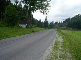
 Klostertaler Gscheid with Chapel Klostertaler Gscheid with Chapel | |
| Elevation | 764 m (2,507 ft) |
| Traversed by | Road |
| Location | Austria |
| Coordinates | 47°48′36″N 15°48′01″E / 47.81000°N 15.80028°E / 47.81000; 15.80028 |
 | |
The Klostertaler Gscheid is a 764 m (AA) high mountain pass in southern Lower Austria, which links the Klostertal valley (municipality of Gutenstein) with the valley of the River Voisbach (municipality of Schwarzau im Gebirge). At the summit of the pass is a small chapel. The tarmac state road Landesstraße 137 runs over the pass. The road runs from northeast to southwest along the northern slopes of the Schneeberg. Because of the sparse population of the region the pass only is only of local significance. It is not closed in winter.
See also
References
- ^ "Klostertaler Gscheid (764 m)". www.quaeldich.de. Retrieved 2024-03-14.
- "Klostertaler Gscheid – Die Alpen" (in German). Retrieved 2024-03-14.
- "RIS - NÖ Landesstraßenverzeichnis - Landesrecht konsolidiert Niederösterreich, Fassung vom 14.03.2024". www.ris.bka.gv.at. Retrieved 2024-03-14.
This Lower Austria location article is a stub. You can help Misplaced Pages by expanding it. |