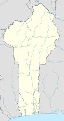
| Klouékanmè | |
|---|---|
| Commune and city | |
 | |
 | |
| Coordinates: 6°58′49″N 1°50′32″E / 6.98028°N 1.84222°E / 6.98028; 1.84222 | |
| Country | |
| Department | Kouffo Department |
| Area | |
| • Total | 100 sq mi (250 km) |
| Population | |
| • Total | 128,537 |
| • Density | 1,331.64/sq mi (514.148/km) |
| Time zone | UTC+1 (WAT) |
Klouékanmè [klu.e.kɑ̃.mɛ] is a town, arrondissement, and commune in the Kouffo Department of south-western Benin. The commune covers an area of 250 square kilometers and as of 2013 had a population of 128,537 people.
Locales within Klouékanmè Arrondissement include Adjanhonmè, Ahogbèya, Aya-Hohoué, Djotto, Hondji, Klouékanmè, Lanta, and Tchikpé.
References
- "National Institute of Statistics and Economic Analysis". Retrieved August 16, 2014.
- "Communes of Benin". Statoids. Archived from the original on March 24, 2012. Retrieved January 5, 2010.
6°58′49″N 1°50′32″E / 6.98028°N 1.84222°E / 6.98028; 1.84222
| Aplahoué |  | |
|---|---|---|
| Djakotomey | ||
| Dogbo | ||
| Klouékanmè | ||
| Lalo | ||
| Toviklin | ||
This Kouffo Department location article is a stub. You can help Misplaced Pages by expanding it. |
