| Konan 湖南市 | |
|---|---|
| City | |
 Konan City Hall Konan City Hall | |
 Flag Flag Emblem Emblem | |
 | |
 | |
| Coordinates: 35°0′N 136°5′E / 35.000°N 136.083°E / 35.000; 136.083 | |
| Country | Japan |
| Region | Kansai |
| Prefecture | Shiga |
| Government | |
| • Mayor | Eigo Tanihata |
| Area | |
| • Total | 70.40 km (27.18 sq mi) |
| Population | |
| • Total | 54,607 |
| • Density | 780/km (2,000/sq mi) |
| Time zone | UTC+9 (Japan Standard Time) |
| - Tree | Utsukushimatsu, a variety of Japanese red pine |
| - Flower | Satsuki azalea |
| - Bird | Japanese bush warbler |
| City Hall address | 1-1 Chūō, Konan-shi, Shiga-ken 520-3288 |
| Website | Official website |

Konan (湖南市, Konan-shi) is a city located in southern Shiga Prefecture, Japan. As of 1 October 2021, the city had an estimated population of 54,607 in 24305 households and a population density of 780 persons per km². The total area of the city is 70.4 square kilometres (27.2 sq mi).
Geography
Konan, as its name implies, is south of Lake Biwa in the center of the southern portion of Shiga Prefecture The city does not actually border the lake. The Ansei Mountains are in the south of the city and the Iwane Mountains in the north, with the Yasu River running from east-to-west through the center.
Neighboring municipalities
Shiga Prefecture
Climate
Konan has a Humid subtropical climate (Köppen Cfa) characterized by warm summers and cool winters with light to no snowfall. The average annual temperature in Konan is 14.1 °C. The average annual rainfall is 1430 mm with September as the wettest month. The temperatures are highest on average in August, at around 26.0 °C, and lowest in January, at around 2.6 °C.
Demographics
Per Japanese census data, the population of Konan increased rapidly in the 1970s but has plateaued in recent decades.
| Year | Pop. | ±% |
|---|---|---|
| 1920 | 10,829 | — |
| 1930 | 11,275 | +4.1% |
| 1940 | 11,291 | +0.1% |
| 1950 | 15,066 | +33.4% |
| 1960 | 15,033 | −0.2% |
| 1970 | 18,646 | +24.0% |
| 1980 | 32,729 | +75.5% |
| 1990 | 46,093 | +40.8% |
| 2000 | 53,740 | +16.6% |
| 2010 | 54,665 | +1.7% |
| 2020 | 54,460 | −0.4% |
History
Konan is part of ancient Ōmi Province and contains Ishibe-juku, the 51st post station on the route of the Tōkaidō highway connecting Heian-kyō with the eastern provinces during the Edo period. The village of Ishibe was established within Kōka District, Shiga with the creation of the modern municipalities system on April 1, 1889. It was elevated to town status on June 1, 1903. On October 1, 2004, Ishibe merged with the neighboring town of Kōsei (also from Kōka District) to form the city of Konan. I
Government
Konan has a mayor-council form of government with a directly elected mayor and a unicameral city council of 18 members. Konan contributes two members to the Shiga Prefectural Assembly. In terms of national politics, the city is part of Shiga 4th district of the lower house of the Diet of Japan.
Economy
The economy of Konan is centered on agriculture and light manufacturing. The Konan Industrial Park on the Meishin Expressway is the largest industrial park in the prefecture.
Education
Konan has nine public elementary schools and four public middle schools operated by the city government. There are two public high schools operated by the Shiga Prefectural Department of Education. The prefecture also operates one special education school for the handicapped.
Transportation
Railway
Highway
Friendship cities
 St. Johns, Michigan, United States, since 2004
Local attractions
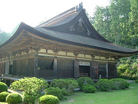
- Chōjū-ji, Buddhist temple with National Treasure main hall
- site of Ishibe-juku
- Jōraku-ji, Buddhist temple with National Treasure main hall and three-story pagoda
- Zensui-ji, Buddhist temple with National Treasure main hall
Notable people
- Kei Aran, actress
- Tenzo Okumura, politician
- Yuta Shimizu, tennis player
References
- "Konan city official statistics" (in Japanese). Japan.
- Konan climate data
- Konan population statistics
- philbert. "Kosei and Ishibe merge to form Konan – Shiga Blog – by Philbert Ono". Retrieved 2020-01-19.
External links
 Media related to Konan, Shiga at Wikimedia Commons
- Konan City official website (in Japanese)
| Ōtsu (capital) | ||
| Core city | ||
| Cities | ||
| Districts | ||
| List of mergers in Shiga Prefecture | ||