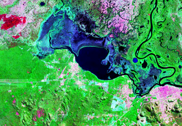
| Laguna Cáceres | |
|---|---|
 Laguna Cáceres Bolivia Satelital map Laguna Cáceres Bolivia Satelital map | |
   | |
| Location | Germán Busch Province, Santa Cruz Department |
| Coordinates | 18°56′S 57°48′W / 18.933°S 57.800°W / -18.933; -57.800 |
| Primary inflows | Río Pimiento, Canal Sicurí |
| Primary outflows | Canal Tamengo |
| Basin countries | Bolivia |
| Surface area | 26.5 to 200 km (10.2 to 77.2 sq mi) |
| Max. depth | 5 m (16 ft) |
| Surface elevation | 150 m (490 ft) |
| Islands | 1 |
Laguna Cáceres is a lake in Germán Busch Province, Santa Cruz Department, Bolivia. At an elevation of 150 m, its surface area is 26.5 to 200 km.
This Santa Cruz Department location article is a stub. You can help Misplaced Pages by expanding it. |