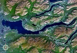
| Lake Keta | |
|---|---|
 from space from space | |
  | |
| Location | Krasnoyarsk Krai |
| Coordinates | 68°41′23″N 90°26′19″E / 68.6897°N 90.4386°E / 68.6897; 90.4386 |
| Primary outflows | Rybnaya River |
| Basin countries | Russia |
| Surface area | 452 km (175 sq mi) |
| Average depth | 80 m (260 ft) |
| Max. depth | 180 m (590 ft) |
Lake Keta (Russian: Кета) is a large freshwater lake in Krasnoyarsk Krai, north-central part of Russia.
Geography
Lake Keta is located in the Putorana Plateau area at 68°41′23″N 90°26′19″E / 68.6897°N 90.4386°E / 68.6897; 90.4386. It has an area of 452 km. The Rybnaya River flows from the lake.
It is located south of Lake Lama and north of Lake Khantayskoye.
See also
References
- "Ozero Keta". Mapcarta. Retrieved 3 May 2016.
- Google Earth
This Krasnoyarsk Krai location article is a stub. You can help Misplaced Pages by expanding it. |