| This article needs additional citations for verification. Please help improve this article by adding citations to reliable sources. Unsourced material may be challenged and removed. Find sources: "Lake Ranau" – news · newspapers · books · scholar · JSTOR (November 2006) (Learn how and when to remove this message) |
| Ranau | |
|---|---|
 Lake Ranau in August 1926 Lake Ranau in August 1926 | |
  | |
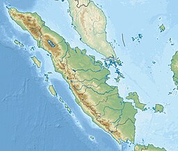
| Location | South Sumatra and Lampung, Indonesia |
| Coordinates | 4°51′45″S 103°55′50″E / 4.86250°S 103.93056°E / -4.86250; 103.93056 |
| Type | Tectonic/ volcanic |
| Primary inflows | Warkuk River |
| Primary outflows | Komering River |
| Basin countries | Indonesia |
| Surface area | 125.9 km (48.6 sq mi) |
| Average depth | 174 m (571 ft) |
| Max. depth | 229 m (751 ft) |
| Water volume | 21.91 km (17,760,000 acre⋅ft) |
| Surface elevation | 540 m (1,770 ft) |
Lake Ranau (Indonesian: Danau Ranau) is a Pleistocene volcanic crater lake in Sumatra, Indonesia.
See also
Notes
- Average depth calculated by dividing volume by surface area.
- "Ranau". Global Volcanism Program. Smithsonian Institution. Retrieved 2021-06-24.
This Indonesia location article is a stub. You can help Misplaced Pages by expanding it. |