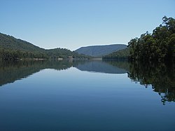
Dam in Hume, Victoria
| William Hovell Dam | |
|---|---|
 A view of Lake William Hovell, looking north towards dam wall A view of Lake William Hovell, looking north towards dam wall | |
 | |
| Country | Australia |
| Location | Hume, Victoria |
| Coordinates | 36°55′14″S 146°23′25″E / 36.92056°S 146.39028°E / -36.92056; 146.39028 |
| Status | Operational |
| Opening date | 1973 |
| Owner(s) | Goulburn-Murray Water |
| Dam and spillways | |
| Type of dam | Embankment dam |
| Impounds | King River |
| Height | 35 m (115 ft) |
| Length | 414 m (1,358 ft) |
| Dam volume | 355×10 |
| Spillway type | Flip bucket chute spillway |
| Spillway capacity | 2,195 m/s (77,500 cu ft/s) |
| Reservoir | |
| Creates | Lake William Hovell |
| Total capacity | 13,500 ML (3.0×10 |
| Surface area | 113 ha (280 acres) |
| William Hovell | |
| Operator(s) | Pacific Hydro |
| Installed capacity | 1.6 MW (2,100 hp) |
| Annual generation | 3.7 GWh (13 TJ) |
| Website Lake William Hovell at http://www.g-mwater.com.au | |
The William Hovell Dam is a rock and earth-fill embankment dam with a flip bucket chute spillway across the King River, operated by Pacific Blue and located in the Hume region of Victoria, Australia. The purposes of the dam are for irrigation and the generation of hydroelectricity. The impounded reservoir is called Lake William Hovell.
The dam and reservoir are named in honour of William Hovell, an explorer.
Location and features
The dam is located south of Whitfield on the edge of the Alpine National Park, fed by the King River and Evans Creek. It supplies water for approximately 24 square kilometres (9.3 sq mi) for irrigated crops, vineyards and grazing properties along the King River from Cheshunt to Wangaratta.
Completed in 1973 the rock and earth–fill dam structure is 35 metres (115 ft) high and 414 metres (1,358 ft) long. The 355-thousand-cubic-metre (12.5×10^ cu ft) dam wall holds back the 13,500-megalitre (3.0×10^ imp gal; 3.6×10^ US gal) Lake William Hovell, when at full capacity, with a surface area of 113 hectares (280 acres). The unusual flip bucket controlled spillway has a discharge capacity of 2,195 cubic metres per second (77,500 cu ft/s). The dam is managed by Goulburn-Murray Water.
Outflow from the dam drives a 1.6 megawatts (2,100 hp) hydro-electric generator, with an average annual output of 3.7 gigawatt-hours (13 TJ), operated by Pacific Blue.
See also
References
- Cox, F; Victoria. State Rivers and Water Supply Commission (1972), The geology of Lake William Hovell Dam: first stage, State Rivers and Water Supply Commission, ISBN 978-0-7241-0492-5
- ^ "Lake William Hovell". Goulburn-Murray Water. Archived from the original on 26 September 2014. Retrieved 11 July 2014.
- ^ "Register of Large Dams in Australia". Dams information. Australian National Committee on Large Dams. 2010. Archived from the original (Excel (requires download)) on 12 December 2013. Retrieved 11 July 2014.
- "Victorian hydro plants". Projects: Operations. Pacific Blue. 2023. Retrieved 7 June 2023.
External links
- "Water in storages - Ovens catchment". Water storage in the basin. Murray-Darling Basin Authority.
| Waterways of the North–East catchment, Victoria, Australia | |
|---|---|
| Rivers | |
| Creeks |
|
| Lakes |
|
| Water supply in Victoria, Australia | |
|---|---|
| Greater Metropolitan Melbourne dams / reservoirs by capacity |
|
| Regional dams / reservoirs |
|
| Other water sources / facilities | |
| Water companies and government agencies |
|
| Historical | |
| Energy in Victoria | |||||||||||
|---|---|---|---|---|---|---|---|---|---|---|---|
| Coal-fired power stations | |||||||||||
| Gas-fired power stations | |||||||||||
| Hydroelectric | |||||||||||
| Wind farms (List) | |||||||||||
| Solar concentrator |
| ||||||||||
| Solar photovoltaic | |||||||||||
| Cogeneration |
| ||||||||||
| Geothermal |
| ||||||||||
| Storage | |||||||||||
| Distributors |
| ||||||||||
| Retailers |
| ||||||||||
| Generators | |||||||||||
| Regulators | |||||||||||
| Historical | |||||||||||
| List of power stations in Victoria | |||||||||||
This article about a location in Victoria, Australia is a stub. You can help Misplaced Pages by expanding it. |