Place in New Brunswick, Canada
| Lamèque | |
|---|---|
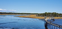
 Aerial view of Lamèque Aerial view of Lamèque | |
 Seal Seal | |
 LamèqueLocation within New Brunswick | |
| Coordinates: 47°47′33″N 64°39′11″W / 47.79246°N 64.65317°W / 47.79246; -64.65317 | |
| Country | Canada |
| Province | New Brunswick |
| County | Gloucester |
| Parish | Shippagan |
| Town | Île-de-Lamèque |
| Founded | 1790 |
| Incorporated (Village) | November 6, 1966 |
| Incorporated (Town) | September 1, 1982 |
| Area | |
| • Land | 12.40 km (4.79 sq mi) |
| Population | |
| • Total | 1,301 |
| • Density | 104.9/km (272/sq mi) |
| • Change (2016–21) | |
| • Dwellings | 606 |
| Time zone | UTC-4 (AST) |
| • Summer (DST) | UTC-3 (ADT) |
| Postal code(s) | E8T |
| Area code | 506 |
| Highways | |
| Website | www |
Lamèque is a former town in Gloucester County, New Brunswick, Canada. It held town status prior to 2023 and is now part of the town of Île-de-Lamèque.
Of Amerindian rather than French origin, "Lamèque" comes from the Micmac Elmugwadasik, a descriptive reference to the fact that "the head of the tidal river is turned to one side". The name of the island approved by the Canadian Permanent Committee on Geographical Names in 1974, the result of a local petition replaced the earlier Shippegan.
History
See also: History of New Brunswick and List of historic places in Gloucester County, New BrunswickA Francophone community, it is situated on Lamèque Island, off the northeastern tip of the Acadian Peninsula. Lamèque has hosted an annual baroque music festival every summer since 1975.
On 1 January 2023, Lamèque amalgamated with the village of Sainte-Marie-Saint-Raphaël and annexed the local service districts making up the remainder of Lamèque Island to form the new town of Île-de-Lamèque. Lamèque's name remains in official use as a community.
Demographics
In the 2021 Census of Population conducted by Statistics Canada, Lamèque had a population of 1,301 living in 577 of its 606 total private dwellings, a change of 1.2% from its 2016 population of 1,285. With a land area of 12.4 km (4.8 sq mi), it had a population density of 104.9/km (271.7/sq mi) in 2021.
Canada census – Lamèque community profile| 2021 | 2016 | 2011 | |
|---|---|---|---|
| Population | 1,301 (+1.2% from 2016) | 1,285 (-10.3% from 2011) | 1,432 (+0.7% from 2006) |
| Land area | 12.40 km (4.79 sq mi) | 12.51 km (4.83 sq mi) | 12.45 km (4.81 sq mi) |
| Population density | 104.9/km (272/sq mi) | 102.8/km (266/sq mi) | 115.1/km (298/sq mi) |
| Median age | 56.0 (M: 53.6, F: 57.6) | 54.0 (M: 53.7, F: 54.3) | 49.9 (M: 49.5, F: 50.4) |
| Private dwellings | 606 (total) 577 (occupied) | 619 (total) | 615 (total) |
| Median household income | $61,600 | $58,880 | $45,362 |
|
|
|
Language
| Canada Census Mother Tongue - Lamèque, New Brunswick | ||||||||||||||||||
|---|---|---|---|---|---|---|---|---|---|---|---|---|---|---|---|---|---|---|
| Census | Total | French | English | French & English | Other | |||||||||||||
| Year | Responses | Count | Trend | Pop % | Count | Trend | Pop % | Count | Trend | Pop % | Count | Trend | Pop % | |||||
| 2011 | 1,370 | 1,360 | 99.27% | 10 | 0.73% | 0 | 0.00% | 0 | 0.00% | |||||||||
| 2006 | 1,330 | 1,330 | 100.00% | 0 | 0.00% | 0 | 0.00% | 0 | 0.00% | |||||||||
| 2001 | 1,495 | 1,480 | 99.00% | 15 | 1.00% | 0 | 0.00% | 0 | 0.00% | |||||||||
| 1996 | 1,590 | 1,560 | n/a | 98.11% | 30 | n/a | 1.89% | 0 | n/a | 0.00% | 0 | n/a | 0.00% | |||||
Economy
Lamèque's economy is tied to the fishing and peat industries.

Attractions
The Lamèque Eco-Parc offers numerous flora and fauna features representative of the Acadian Peninsula.
Notable people
Main article: List of people from Gloucester County, New BrunswickSee also
References
- ^ "Census Profile of Lamèque". Statistics Canada. 6 December 2022. Retrieved 17 January 2023.
- Hamilton, William (1978). The Macmillan Book of Canadian Place Names. Toronto: Macmillan. p. 78. ISBN 0-7715-9754-1.
- Frommers. Acadian Peninsula
- "Local Governments Establishment Regulation – Local Governance Act". Government of New Brunswick. 12 October 2022. Retrieved 11 January 2023.
- "RSC 4 Acadian Peninsula Regional Service Commission". Government of New Brunswick. Retrieved 17 January 2023.
- "Proposed entity names reflect strong ties to nature and history" (Press release). Irishtown, New Brunswick: Government of New Brunswick. 25 May 2022. Retrieved 20 January 2023.
- "2021 Community Profiles". 2021 Canadian census. Statistics Canada. February 4, 2022. Retrieved 2023-10-19.
- "2016 Community Profiles". 2016 Canadian census. Statistics Canada. August 12, 2021. Retrieved 2019-08-15.
- "2011 Community Profiles". 2011 Canadian census. Statistics Canada. March 21, 2019. Retrieved 2014-04-05.
- "2006 Community Profiles". 2006 Canadian census. Statistics Canada. August 20, 2019.
- "2001 Community Profiles". 2001 Canadian census. Statistics Canada. July 18, 2021.
- ^ Statistics Canada: 1996, 2001, 2006, 2011 census
- "Census Profile, 2016 Census: Lamèque, New Brunswick". Statistics Canada. Retrieved August 15, 2019.
External links
- (in French) Ville de Lameque
| Subdivisions of New Brunswick | |
|---|---|
| Cities | |
| Towns |
|
| Villages | |
| Regional municipality | |
| Rural communities | |
| Rural districts |
|
| Regional service commissions | |
| School districts | |
| Indian reserves |
|
| Non-administrative divisions | |