| Langtauferer Spitze | |
|---|---|
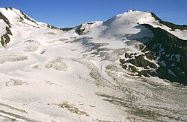
 Langtauferer Spitze from the southeast over the Hintereisferner. All the way on the left is the Weißkugel. Langtauferer Spitze from the southeast over the Hintereisferner. All the way on the left is the Weißkugel. | |
| Highest point | |
| Elevation | 3,529 m (11,578 ft) |
| Prominence | 177 m (581 ft) |
| Parent peak | Weißkugel |
| Coordinates | 46°48′17″N 10°44′45″E / 46.80472°N 10.74583°E / 46.80472; 10.74583 |
| Geography | |
 | |
| Location | Tyrol, Austria / South Tyrol, Italy |
| Parent range | Ötztal Alps |
| Climbing | |
| First ascent | 1865 by D. W. Freshfield, W. H. Fox, F. F. Tuckett, F. Devouassoud and P. Michel |
The Langtauferer Spitze is a mountain in the Weisskamm group of the Ötztal Alps on the border between Tyrol, Austria, and South Tyrol, Italy.
References
- Klier 2016. sfn error: no target: CITEREFKlier2016 (help)
Sources
- Klier, Walter (2006). Ötztaler Alpen. Bergverlag Rother. ISBN 978-3-7633-1123-1.
- Alpenvereinskarte Blatt 30/2, 1:25.000, Ötztaler Alpen, Weißkugel. ISBN 3-928777-39-4
External links
![]() Media related to Langtauferer Spitze at Wikimedia Commons
Media related to Langtauferer Spitze at Wikimedia Commons
This Tyrol location article is a stub. You can help Misplaced Pages by expanding it. |