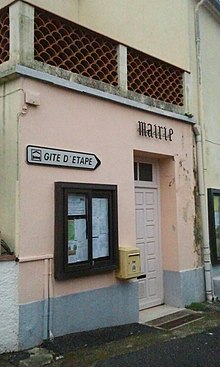
Las Illas (in Catalan: Les Illes) is a former commune in Pyrénées-Orientales (France), now part of Maureillas-las-Illas.
Geography
Las Illas is located south of Maureillas and north of Maçanet de Cabrenys (Catalonia, Spain).
History
Las Illas became a commune in 1790.
Las Illas was only linked to the electricity network on 26 July 1955. The commune had repeatedly asked to have electricity since 1923.
On 20 June 1972, Las Illas was linked with Maureillas and Riunoguès to create the new commune of Maureillas-las-Illas.
Politics and administration

Mayors
| Mayor | Term start | Term end |
|---|---|---|
| François Dabouzi | 1945 | 1947 |
| Antoine Auriol | 1947 | 1952 |
| François Dabouzi | 1952 | 1953 |
| Marguerite Dabouzi | March 1965 | June 1965 |
| René Guidicelli | 1965? | ? |
| Raymond Commenge | ? | 1972 |
Demography
Demography of Las Illas.
Population under the Ancien Régime is calculated either in number of feu fiscal (f, fire tax), or in number of inhabitants.
| 1365 f | 1378 f | 1470 f | 1515 f | 1553 f | 1720 f | 1730 f | 1755 f | 1767 | 1774 | 1789 f | 1794 | 1795 | 1796 |
|---|---|---|---|---|---|---|---|---|---|---|---|---|---|
| 14 | 12 | 4 | 4 | 3 | 5 | 7 | 20 | 110 | 84 | 24 | 91 | 101 | 104 |
| 1800 | 1804 | 1806 | 1820 | 1826 | 1831 | 1836 | 1841 | 1846 | 1851 | 1856 | 1861 | 1866 | 1872 | 1876 | 1881 |
|---|---|---|---|---|---|---|---|---|---|---|---|---|---|---|---|
| 131 | 122 | 129 | 205 | 236 | 269 | 249 | 233 | 281 | 289 | 305 | 280 | 264 | 314 | 237 | 237 |
| 1886 | 1891 | 1896 | 1901 | 1906 | 1911 | 1921 | 1926 | 1931 | 1936 | 1946 | 1954 | 1962 | 1968 |
|---|---|---|---|---|---|---|---|---|---|---|---|---|---|
| 228 | 198 | 181 | 191 | 209 | 192 | 119 | 119 | 85 | 84 | 119 | 67 | 57 | 60 |
After 1975, see Maureillas-las-Illas#Population
Sites of interest
- The romanesque church of Notre-Dame du Remède.
- The war memorial.
See also
Notes
- Cárdenas, Fabricio (2014). 66 petites histoires du Pays Catalan [66 Little Stories of Catalan Country] (in French). Perpignan: Ultima Necat. ISBN 978-2-36771-006-8. OCLC 893847466.
- ^ Jean-Pierre Pélissier, Paroisses et communes de France : dictionnaire d'histoire administrative et démographique, vol. 66 : Pyrénées-Orientales, Paris, CNRS, 1986, 378 p. (ISBN 2-222-03821-9)
- ^ André Balent, Dabouzi, François, Dictionnaire Maitron
42°25′33″N 2°47′06″E / 42.42583°N 2.78500°E / 42.42583; 2.78500
This Pyrénées-Orientales geographical article is a stub. You can help Misplaced Pages by expanding it. |

