| Châtelet-sur-Retourne–Juniville–Vouziers | |||||||||||||||||||||||||||||||||||||||||||||||||||||||||||||||||||||||||||||||||||||||||||||||||||||||||||||||||||||||||||||||||||||||||||||||||
|---|---|---|---|---|---|---|---|---|---|---|---|---|---|---|---|---|---|---|---|---|---|---|---|---|---|---|---|---|---|---|---|---|---|---|---|---|---|---|---|---|---|---|---|---|---|---|---|---|---|---|---|---|---|---|---|---|---|---|---|---|---|---|---|---|---|---|---|---|---|---|---|---|---|---|---|---|---|---|---|---|---|---|---|---|---|---|---|---|---|---|---|---|---|---|---|---|---|---|---|---|---|---|---|---|---|---|---|---|---|---|---|---|---|---|---|---|---|---|---|---|---|---|---|---|---|---|---|---|---|---|---|---|---|---|---|---|---|---|---|---|---|---|---|---|---|
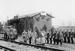
 German soldiers during the opening ceremony on 3 May 1916 in Machault German soldiers during the opening ceremony on 3 May 1916 in Machault Former route of the track superimposed onto a modern map | |||||||||||||||||||||||||||||||||||||||||||||||||||||||||||||||||||||||||||||||||||||||||||||||||||||||||||||||||||||||||||||||||||||||||||||||||
| Technical | |||||||||||||||||||||||||||||||||||||||||||||||||||||||||||||||||||||||||||||||||||||||||||||||||||||||||||||||||||||||||||||||||||||||||||||||||
| Line length | 42 kilometres (30 mi) | ||||||||||||||||||||||||||||||||||||||||||||||||||||||||||||||||||||||||||||||||||||||||||||||||||||||||||||||||||||||||||||||||||||||||||||||||
| Track gauge | Tramway: 600 mm (1 ft 11+5⁄8 in) CA, initially: 800 mm (2 ft 7+1⁄2 in) | ||||||||||||||||||||||||||||||||||||||||||||||||||||||||||||||||||||||||||||||||||||||||||||||||||||||||||||||||||||||||||||||||||||||||||||||||
| |||||||||||||||||||||||||||||||||||||||||||||||||||||||||||||||||||||||||||||||||||||||||||||||||||||||||||||||||||||||||||||||||||||||||||||||||
The Le Châtelet-sur-Retourne–Juniville–Vouziers railway line was a 42 kilometres (30 mi) long railway line in the north of France with a gauge of initially 800 mm (2 ft 7+1⁄2 in) and later 1,000 mm (3 ft 3+3⁄8 in).
History
Narrow gauge and metre gauge railway
The line was built with a gauge of 800 mm (2 ft 7+1⁄2 in) for strategic reasons, to make it difficult for an enemy army to use in the event of an invasion. Even after the ban on the use of metre gauge had been lifted and most of the lines of the operating company had been converted to metre gauge, the unusual gauge was still maintained.
The 9 kilometres (5.6 mi) narrow gauge section from Le Châtelet-sur-Retourne to Juniville was put into service on 10 December 1900 and inaugurated on 10 February 1901 by the Chemins de fer départementaux des Ardennes (CA).
The narrow-gauge section from Juniville to Vouziers was put into service on 25 November 1906. The narrow-gauge line was converted to metre gauge in 1924. It was operated until 1933.
 Menck & Hambrock steam shovel und Oberursel internal combustion engine locomotive near Semide
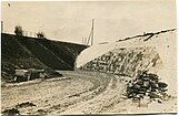
 German 600-mm-gauge railway of Railway Pioneer Company 13 in the cutting near Le Châtelet
 Train with a rake of V-skip trucks operated by the German Railway Pioneer Company 13 near Le Châtelet
 German Railway Pioneer Company 13 near Le Châtelet
 Starting point of the military railway constructed by the German Railway Pioneer Company 13 near Le Châtelet
 German standard gauge locomotive in the cutting near Le Châtelet
 German military railway station near Semide
German military railway
During World War I, the German forces built a standard gauge military railway in the area. It was ceremonially put into operation by the German troops in Machault on 3 May 1916. Among other things, it was used to transport the German naval gun "Langer Max" (38-cm SK-L/45) to its installation site 2 kilometres (1.2 mi) southeast of Semide. The re-routing required extensive earthworks with deep and long cuts and high embankments, which German soldiers carried out with the help of an Oberursel benzene locomotive as well as with dump truck trains loaded by hand and by a Menck & Hambrock steam shovel excavator. The light railway used by the Bavarian Reserve Railway Construction Company 1 and the Railway Pioneer Company 13 during the construction work had a track gauge of 600 mm (1 ft 11+5⁄8 in).
Langer Max


 German naval gun "Langer Max" (38-cm SK-L/45) 2 kilometres (1.2 mi) southeast of Semide
The construction of a new position for the naval gun "Langer Max" began in March 1916. The Chief of Staff of the 3rd Army, Colonel Fritz von Lossberg reported to the Supreme Army Command (Oberste Heeresleitung, O.H.L.) on 19 May 1916 that the gun would be ready for action near Semide from 22 May 1916. It was to be used to fire at two railway junctions at a suitable time without revealing the top secret location of the well camouflaged gun too early. In August 1916, the 3rd Army received 25 rounds of 38-cm ammunition by order of the Supreme Army Command.
As ordered by the 3rd Army Chief of Staff, Martin Freiherr von Oldershausen on 3 November 1916, the gun fired 15 shells at the triangular junction near Saint-Hilaire-au-Temple, some 35 kilometres (20 mi) to the southwest, on 10 November 1916. According to French accounts, there was no significant damage to property and no casualties. On 11 and 15 November 1916, Sainte-Menehould was shelled with the remaining 10 shells, reportedly resulting in several wounded.
Stations
| Station | Photo | Comment |
|---|---|---|
| Le Châtelet-sur-Retourne |  |
Temporary station building after the destruction of the original building in the First World War. |
| Neuflize |  |
|
| Alincourt |  |
|
| Juniville |  |
|
| Bignicourt | ||
| Ville-sur-Retourne | ||
| Pauvres |  |
|
| Mont-Saint-Remy | ||
| Machault |  |
|
| Semide |  |
|
| Contreuve |  |
The German station of Contreuve: In the foreground the standard gauge railway with 1435 mm gauge and in the background probably a light railway with 600 mm gauge. |
| Sugny | ||
| Sainte-Marie | ||
| Vouziers-Marizy |  |
|
| Vouziers |  |
References
- IGN: Remonter le Temps.
- ^ Stefan Schweitzer: Langer Max – 38-cm-SK-L/45 vor Verdun.
- Chemins de fer départementaux des Ardennes. Le Châtelet-sur-Retourne a Vouziers. 1914.
- "Opening of the Châtelet-Juniville local railway. The Châtelet-Juniville local railway, built by the Directorate of the French Eastern Railway, was opened to traffic on 10 February (1901). The 9 km long line, located in the department of Ardennes, branches off from Châtelet station of the Bozancourt - Châtelet - Mözieres section of the main Paris - Reims - Bozancourt - Charleville - Longuion - Luxembourg and Longuion - Metz line." („Eröffnung der Localbahn Châtelet–Juniville. Die von der Direction der Französischen Ostbahn erbaute Localbahn Châtelet-Juniville wurde am 10. Februar (1901) dem Betriebe übergeben. Die im Departement Ardennes liegende 9 km lange Linie zweigt von der Station Châtelet der Theilstrecke Bozancourt — Châtelet — Mözieres der gesellschaftlichen Hauptlinie Paris — Reims — Bozancourt — Charleville — Longuion — Luxembourg und Longuion — Metz ab.“) In: Verordnungsblatt für Eisenbahnen und Schiffahrt: Mit den “Veröffentlichungen in tarif- und transportangelegenheiten”. Redigiert im k. k. Eisenbahnministerium im Einvernehmen mit dem k. k. Handelsministerium. 1901. Page 966.
- ^ Société des CFD à voie étroite des Ardennes.
- List of the chemins de fer secondaires.
- David Murzyn: La voie ferrée de Vouziers à Semide.
