Dam in Pitminster, Somerset
| Leigh Reservoir | |
|---|---|
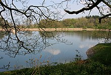
 The reservoir in April 2009 The reservoir in April 2009 | |
 | |
| Country | England |
| Location | Pitminster, Somerset |
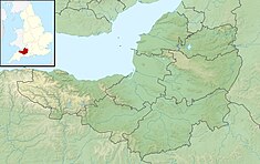
| Coordinates | 50°57′10″N 3°08′40″W / 50.952712°N 3.144439°W / 50.952712; -3.144439 |
| Status | Full |
| Opening date | 1893 |
| Operator(s) | Wessex Water |
| Reservoir | |
| Catchment area | 20.5 hectares (51 acres) |
| Surface area | 2.128 hectares (5.26 acres) |
| Normal elevation | 160 metres (520 ft) |
Leigh Reservoir, or Leigh Hill Reservoir, is a small reservoir in Somerset, England. It was built in 1893 to supply water to the town of Taunton, Somerset, which lies to the north. Water quality is good.
Location
Leigh Reservoir is an artificial lake in the parish of Pitminster, Somerset, 15.1 kilometres (9.4 mi) from the sea. It is to the west of Luxhay Reservoir and south of the village of Lowton, near to Angersleigh. It is 160 metres (520 ft) above sea level. The reservoir is near the southern boundary of the River Tone catchment basin. In 1912 the reservoir had an 8 inches (200 mm) rain gauge 1.5 feet (0.46 m) above ground that recorded rainfall on 180 days of 43.34 inches (1,101 mm) in total.
Description
A plaque on the reservoir is dated 1893, and gives the surface area of water as 6 acres (2.4 ha) and greatest depth 38 feet (12 m). It was to contain 26,000,000 imperial gallons (120,000,000 L; 31,000,000 US gal). The reservoir was built by Bond & Hitchcock, contractors. It was operated by the Taunton Waterworks. The reservoir today has an average depth of 1.33 metres (4 ft 4 in) and a surface area of 2.128 hectares (5.26 acres), with a catchment area of 20.5 hectares (51 acres). The perimeter is 0.6 kilometres (0.37 mi).
Leigh and Luxhay reservoirs are managed today by Wessex Water. In 2013 Wessex Water arranged for installation of physical and electronic security systems in both reservoirs, using a system of pontoons during installation. Leigh Reservoir is accessed via a single entry point on top. A secure access cover was installed, enclosed in a high security cage.
Water quality
During the Routine Monitoring Programme of 1990 the reservoir was listed as containing "abundant" blue-green algae. No bloom or scum were observed, although there was scum on Luxhay Reservoir. Leigh Reservoir is one of three in the Tone catchment that are monitored under the EC Surface Water Abstraction Directive, the others being the Clatworthy Reservoir and Luxhay Reservoir. A 1998 report said that none of these reservoirs had exceeded the standard for dissolved and emulsified hydrocarbons since UV fluorescence tests began in September 1997. As of 2015 water quality was good both chemically and ecologically.
Notes
- ^ Leigh Reservoir – British Lakes.
- Leigh Reservoir – Environment Agency, map.
- ^ Leigh Reservoir – Environment Agency.
- Turner 1998, p. 1.
- Mill & Salter 1913, p. 264.
- Chipchase 2009.
- Wright 2015, p. 281.
- Miles 2013.
- NRA Report of the Blue-Green Algal Monitoring 1990, p. 30.
- NRA Report of the Blue-Green Algal Monitoring 1990, p. 38.
- Turner 1998, p. 5.
Sources
- Chipchase, Nick (20 April 2009), Leigh Hill Reservoir - plaque, retrieved 21 August 2016
- "Leigh Reservoir", British Lakes, retrieved 21 August 2016
- Leigh Reservoir, Environment Agency, retrieved 21 August 2016
- Miles, Michael (October 2013), Towering Feat of Security for Wessex Water, Technocover, retrieved 21 August 2016
- Mill, Hugh Robert; Salter, Carle (1913), "Division V. - South Western Counties", British Rainfall, 1912 (PDF), London: Edward Stanford, retrieved 21 August 2016
- NRA Report of the Blue-Green Algal Monitoring 1990 (PDF), National Rivers Authority, Anglian Region, June 1991, retrieved 21 August 2016
- Turner, Alan (1998), First Annual Review of the River Tone Catchment Management Plan (PDF), retrieved 21 August 2016
- Wright, Brian (25 November 2015), Andrew Crosse and the mite that shocked the world: The life and work of an electrical pioneer, Troubador Publishing Ltd, ISBN 978-1-78462-438-5, retrieved 21 August 2016
External links
![]() Media related to Leigh Reservoir at Wikimedia Commons
Media related to Leigh Reservoir at Wikimedia Commons