| Lesum | |
|---|---|
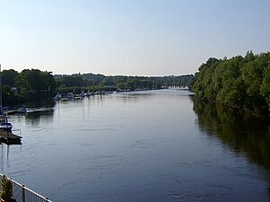
 Mouth of the Lesum near Vegesack Mouth of the Lesum near Vegesack | |
| Location | |
| Country | Germany |
| State | Bremen |
| City | Bremen |
| Physical characteristics | |
| Source | |
| • location | Confluence of the Wümme and Hamme rivers near Ritterhude |
| • coordinates | 53°10′17″N 8°44′33″E / 53.17139°N 8.74250°E / 53.17139; 8.74250 |
| • elevation | 4 m (13 ft) |
| Mouth | Weser |
| • location | Bremen-Vegesack |
| • coordinates | 53°10′0″N 8°37′28″E / 53.16667°N 8.62444°E / 53.16667; 8.62444 |
| • elevation | 4 m (13 ft) |
| Length | 9.85 km (6.12 mi) |
| Basin size | 2,187 km (844 sq mi) |
| Basin features | |
| Progression | Weser→ North Sea |
| Tributaries | |
| • left | Wümme |
| • right | Hamme |
The Lesum is a 9.85-kilometre-long (6 mi) river in northern Germany, right tributary of the Weser, navigable for Class III ships. It is formed at the confluence of the rivers Wümme and Hamme, near Ritterhude, northwest of Bremen. It flows west and flows into the Weser in Bremen-Vegesack.
See also
References
- Environmental map service of Lower Saxony (Umweltkartendienst des Niedersächsischen Ministeriums für Umwelt, Energie und Klimaschutz)
- Längen der Hauptschifffahrtswege der Binnenwasserstraßen des Bundes, Liste 4, Bundesministerium für Verkehr und digitale Infrastruktur
This Bremen location article is a stub. You can help Misplaced Pages by expanding it. |
This article related to a river in Lower Saxony is a stub. You can help Misplaced Pages by expanding it. |