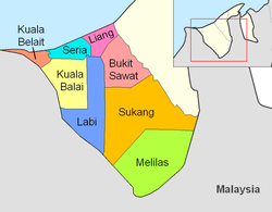
Mukim in Belait, Brunei
| Mukim Liang | |
|---|---|
| Mukim | |
    Clockwise from top left: Lumut, Brunei Fertilizer Industries, Zainab Mosque, Sungai Gana
 | |
 Liang is in pink. Liang is in pink. | |
| Coordinates: 4°39′36″N 114°27′32″E / 4.66000°N 114.45889°E / 4.66000; 114.45889 | |
| Country | Brunei |
| District | Belait |
| Government | |
| • Penghulu | Yamin Abdul Ranni |
| Population | |
| • Total | 16,813 |
| Time zone | UTC+8 (BNT) |
| Postcode | KCxx35 |
Mukim Liang is a mukim in Belait District, Brunei. The population was 14,301 in 2016.
Geography
The mukim is located in the north of the district, bordering the South China Sea to the north, Mukim Telisai in Tutong District to the north-east, Mukim Bukit Sawat to the south-east, Mukim Labi to the south and Mukim Seria to the west.
Demographics
As of 2016 census, the population was 14,301 with 51.4% males and 48.6% females. The mukim had 2,607 households occupying 2,602 dwellings. Among the population, 32.3% lived in urban areas, while the remainder of 67.7% lived in rural areas.
Administration
As of 2021, the mukim comprised the following villages:
| Settlements | Population (2021) | Ketua kampung (2024) |
|---|---|---|
| Kampong Sungai Tali | 1,051 | Haji Khairdon bin Haji Dahlan |
| Kampong Sungai Taring | 857 | |
| Kampong Sungai Bakong | 1,642 | Taib bin Haji Salleh |
| Kampong Sungai Kuru | 495 | |
| Kampong Lumut | 171 | |
| Kampong Lumut Camp | 864 | — |
| RPN Kampong Lumut Area 1 | 2,035 | Saini bin Ismail |
| RPN Kampong Lumut Area 2 | 5,605 | Salleh bin Haji Bujang |
| Kampong Lumut Tersusun | 1,205 | Taib bin Haji Salleh |
| Kampong Sungai Kang | 56 | |
| Kampong Sungai Lalit | 397 | |
| Kampong Agis-Agis | 217 | |
| Kampong Perumpong | 427 | — |
| Kampong Sungai Liang | 641 | Mohammad Haszrin bin Bagol |
| Kampong Tunggulian | 656 | — |
| Kampong Lilas | 148 | |
| Kampong Sungai Gana | 160 | |
| Kampong Keluyoh | 186 |
References
- ^ BUKU DIREKTORI TELEFON PENGHULU-PENGHULU MUKIM DAN KETUA-KETUA KAMPUNG NEGARA BRUNEI DARUSSALAM (PDF) (in Malay). Vol. 4. Brunei: Bahagian Perancangan Daerah, Ministry of Home Affairs. April 2024. p. 22.
- ^ "Annex B" (PDF). DEPS.MoFE.gov.bn. Department of Economic Planning and Statistics, Ministry of Finance and Economy. October 2021. Retrieved 23 January 2024.
- "Belait District" (PDF). www.information.gov.bn. 2011. pp. 8–9. Retrieved 28 June 2021.
- ^ "Population and Housing Census Update Final Report 2016" (PDF). www.deps.gov.bn. Statistics Department. December 2018. Retrieved 27 June 2021.
- Brunei Darussalam street directory : quick & easy reference maps., Brunei. Juruukur Agung., Brunei Press Sdn. Bhd., Published & printed by Brunei Press Sdn. Bhd., Commercial Printing Services, 2014, ISBN 9789991732411, OCLC 932264901
{{citation}}: CS1 maint: others (link) - "Direktori Penghulu, Ketua Kampung, dan Ketua Rumah Panjang". Jabatan Daerah Belait (in Malay). Retrieved 20 August 2024.
| Mukims of Brunei Darussalam | ||
|---|---|---|
| Belait |  | |
| Brunei–Muara | ||
| Temburong | ||
| Tutong | ||
| administrative divisions | ||
This Brunei location article is a stub. You can help Misplaced Pages by expanding it. |