Misplaced Pages

List of Cultural Properties of Japan – historical materials (Yamaguchi)

Article snapshot taken from Wikipedia with creative commons attribution-sharealike license. Give it a read and then ask your questions in the chat. We can research this topic together.

Map all coordinates using OpenStreetMap

Download coordinates as:

This list is of the Cultural Properties of Japan designated in the category of historical materials (歴史資料, rekishi shiryō) for the Prefecture of Yamaguchi.

National Cultural Properties

As of 1 September 2020, eight Important Cultural Properties have been designated, being of national significance.

Property Date Municipality Ownership Comments Image Coordinates Ref.
Items such as seals relating to the tally trade of the Ōuchi clan
大内氏勘合貿易印等関係資料
Ōuchi-shi kangō bōeki in-tō kankei shiryō
Muromachi period Hōfu Mōri Museum 5 items 34°03′48″N 131°35′18″E / 34.06346°N 131.5883°E / 34.06346; 131.5883 (Mōri Museum)
Ōuchi Edition Lotus Sūtra Woodblocks
大内版法華経板木
Ōuchi-ban hokekyō hangi
Muromachi period Yamaguchi Yamaguchi Prefecture
(kept at Yamaguchi Prefectural Archives)
59 woodblocks 34°10′53″N 131°28′35″E / 34.1815°N 131.4763°E / 34.1815; 131.4763 (Yamaguchi Prefectural Archives)
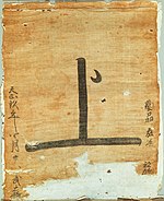
Ship flag pass
Noshima Murakami Family Documents
過所船旗〈天正九年四月廿八日/〉
能島村上家文書
kasho sen-ki
Noshima Murakami-ke monjo
C16 Yamaguchi Yamaguchi Prefectural Archives 199 documents plus 1 flag pass of Tenshō 9 (1581); cf. Japan Heritage "Story" #036 34°10′53″N 131°28′35″E / 34.1815°N 131.4763°E / 34.1815; 131.4763 (Yamaguchi Prefectural Archives)
Keichō Kuniezu - retained copies of Suō Province & Nagato Province
慶長国絵図〈控図/周防国、長門国〉
Keichō kuniezu (hikaezu / Suō-no-kuni, Nagato-no-kuni)
Edo period Ube Ube City
(kept at Ube Bunka Kaikan (宇部市文化会館))
2 maps 33°57′28″N 131°14′39″E / 33.95784°N 131.2443°E / 33.95784; 131.2443 (Ube Bunka Kaikan)
Gifts of the Joseon mission to Japan in Shōtoku 1 (1711) together with a catalogue of these gifts
正徳元年朝鮮通信使進物並進物目録
Shōtoku gannen Chōsen tsūshinshi shinmotsu narabini shinmotsu mokuroku
Edo period Yamaguchi Yamaguchi Prefecture
(kept at Yamaguchi Prefectural Museum)
106 items 34°10′57″N 131°28′22″E / 34.18246°N 131.4727°E / 34.18246; 131.4727 (Yamaguchi Prefectural Museum)
Japan-Ming trade ship flag
Takasu Family Documents
日明貿易船旗〈万暦十二年十月吉日/(麻布)〉
高洲家文書
Nichi-Min bōeki sen-ki
Takasu-ke monjo
1351–1643 Yamaguchi private
(kept at Yamaguchi Prefectural Archives)
117 documents plus 1 flag of Wanli 12 (1584) 34°10′53″N 131°28′35″E / 34.1815°N 131.4763°E / 34.1815; 131.4763 (Yamaguchi Prefectural Archives)
Earthen-moulded papier-mâché maps of Suō and Nagato Provinces
防長土図
Bōchō dozu
1767 Yamaguchi Yamaguchi Prefecture
(kept at Yamaguchi Prefectural Museum)
109 items; by Arima Kisōta (有馬喜惣太) 34°10′57″N 131°28′22″E / 34.18246°N 131.4727°E / 34.18246; 131.4727 (Yamaguchi Prefectural Museum)
Administrative documents of Yamaguchi Prefecture
山口県行政文書
Yamaguchi-ken gyōsei bunsho
Edo period to Shōwa era Yamaguchi Yamaguchi Prefecture
(kept at Yamaguchi Prefectural Archives)
13,549 items 34°10′53″N 131°28′35″E / 34.1815°N 131.4763°E / 34.1815; 131.4763 (Yamaguchi Prefectural Archives)
This list is complete and up to date as of September 2020.

Prefectural Cultural Properties

As of 1 May 2020, sixteen properties have been designated at a prefectural level.

Property Date Municipality Ownership Comments Image Coordinates Ref.
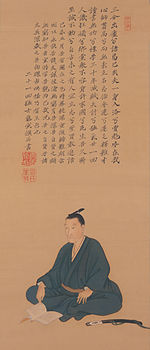
Items relating to Yoshida Shōin (handed down in the Yoshida Family)
吉田松陰関係資料(吉田家伝来)
Yoshida Shōin kankei shiryō (Yoshida-ke denrai)
1699–1921 Yamaguchi Yamaguchi Prefecture
(kept at Yamaguchi Prefectural Archives)
754 items including 741 documents and 1 portrait 34°10′53″N 131°28′35″E / 34.1815°N 131.4763°E / 34.1815; 131.4763 (Yamaguchi Prefectural Archives)
Items relating to Mōri Motonari
毛利元就関係資料
Mōri Motonari kankei shiryō
Muromachi period Hōfu Mōri Museum 34°03′48″N 131°35′18″E / 34.06346°N 131.5883°E / 34.06346; 131.5883 (Mōri Museum)
Items relating to Mōri Takamoto
毛利隆元関係資料
Mōri Takamoto kankei shiryō
late Muromachi period Hōfu Mōri Museum 34°03′48″N 131°35′18″E / 34.06346°N 131.5883°E / 34.06346; 131.5883 (Mōri Museum)
Items relating to Mōri Terumoto
毛利輝元関係資料
Mōri Terumoto kankei shiryō
Muromachi period to early Edo period Hōfu Mōri Museum 34°03′48″N 131°35′18″E / 34.06346°N 131.5883°E / 34.06346; 131.5883 (Mōri Museum)
Items relating to Mōri Hidenari
毛利秀就関係資料
Mōri Hidenari kankei shiryō
early Edo period Hōfu Mōri Museum 34°03′48″N 131°35′18″E / 34.06346°N 131.5883°E / 34.06346; 131.5883 (Mōri Museum)
Cultural Properties of Japan - historical materials
Hokkaidō
Tōhoku
Kantō
Chūbu
Kansai
Chūgoku
Shikoku
Kyūshū
Okinawa

See also

References

  1. "Cultural Properties for Future Generations". Agency for Cultural Affairs. Retrieved 8 September 2020.
  2. 国宝・重要文化財 [Number of National Treasures and Important Cultural Properties by Prefecture] (in Japanese). Agency for Cultural Affairs. 1 September 2020. Retrieved 8 September 2020.
  3. "Database of National Cultural Properties: 国宝・重要文化財(美術品)(歴史資料 山口県)" (in Japanese). Agency for Cultural Affairs. Retrieved 8 September 2020.
  4. ^ 指定文化財の検索(一覧から選ぶ) [List of National and Prefectural Cultural] (in Japanese). Yamaguchi Prefecture. Retrieved 8 September 2020.
  5. Kawamura Hidetada (1997). "A Papier-Mâché Relief Map: The 'Bocho-Dozu' from the Edo Era in Japan". Imago Mundi. 49: 83–89. doi:10.1080/03085699708592860. JSTOR 1151335.
  6. 都道府県別指定等文化財件数(都道府県分) [Number of Prefectural Cultural Properties by Prefecture] (in Japanese). Agency for Cultural Affairs. 1 May 2020. Retrieved 8 September 2020.

External links

Categories: