| This article relies largely or entirely on a single source. Relevant discussion may be found on the talk page. Please help improve this article by introducing citations to additional sources. Find sources: "List of Interstate Highways in North Dakota" – news · newspapers · books · scholar · JSTOR (December 2023) |
  Sample markers Sample markers | |
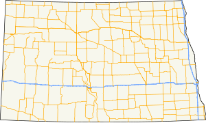
 Map of North Dakota highway system with Interstates highlighted in blue Map of North Dakota highway system with Interstates highlighted in blue | |
| Highway names | |
|---|---|
| Interstates | Interstate X (I-X) |
| US Highways | U.S. Route X (US X) |
| State | N.D. Highway X (ND X) |
| System links | |
| |
The Interstate Highways in North Dakota are the segments of the Dwight D. Eisenhower National System of Interstate and Defense Highways owned and maintained by the North Dakota Department of Transportation (NDDOT) in the US state of North Dakota.
Mainline highways
| Number | Length (mi) | Length (km) | Southern or western terminus | Northern or eastern terminus | Formed | Removed | Notes | |
|---|---|---|---|---|---|---|---|---|
| 217.517 | 350.060 | I-29/U.S. 81 at South Dakota state line | PTH 75 at Canada–US border near Pembina | 01958-01-011958 | current | |||
| 154 | 248 | I-94/U.S. 52 in Fargo | PTH 75 at Canada–US border near Pembina | 01957-01-011957 | 01958-01-011958 | Replaced by I-29 | ||
| 352.454 | 567.220 | I-94 at Montana state line | I-94 / US 52 at Minnesota state line | 01958-01-011958 | current | |||
| 1.072 | 1.725 | I-94 in Mandan | ND 810 in Bismarck | 01958-01-011958 | current | Part of the Bismarck Expressway; I-194 is unsigned | ||
| ||||||||
Business routes
| Number | Length (mi) | Length (km) | Southern or western terminus | Northern or eastern terminus | Formed | Removed | Notes | |
|---|---|---|---|---|---|---|---|---|
| — | — | — | — | — | — | Serves Medora | ||
| — | — | — | — | — | — | Serves Dickinson | ||
| — | — | — | — | — | — | Serves Mandan and Bismarck | ||
| — | — | — | — | — | 02004-01-012004 | Served Jamestown | ||
| — | — | — | — | — | — | Serves Valley City | ||
| — | — | — | — | — | — | Serves Fargo | ||
See also
References
- Cartography Section, Planning/Asset Management Section (2015). Route and Mileage Map (PDF) (Map). c. 1:1,900,800. Bismarck: North Dakota Department of Transportation. Retrieved August 14, 2016.
- "Overview map of I-31" (Map). Google Maps. Retrieved January 17, 2024.
- Official Route Numbering for the National System of Interstate and Defense Highways, August 14, 1957
- Official Route Numbering for the National System of Interstate and Defense Highways, June 27, 1958
External links
 Media related to Interstate Highways in North Dakota at Wikimedia Commons