Unincorporated community in Arkansas, United States
| Little Dixie, Arkansas | |
|---|---|
| Unincorporated community | |
  | |
| Coordinates: 35°00′26″N 91°21′53″W / 35.00722°N 91.36472°W / 35.00722; -91.36472 | |
| Country | United States |
| State | Arkansas |
| Counties | Prairie, Woodruff |
| Elevation | 180 ft (50 m) |
| Time zone | UTC-6 (Central (CST)) |
| • Summer (DST) | UTC-5 (CDT) |
| Area code | 870 |
| GNIS feature ID | 58073 |
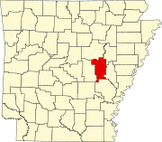
Little Dixie is an unincorporated community in Prairie and Woodruff counties, Arkansas, United States. It is located about 8 miles east-northeast of Des Arc, about 13 miles northwest of Brinkley, and about 19 miles south of Augusta, Arkansas. It sits at the intersection of State Highway 33 and State Highway 38.
Notes
- ^ U.S. Geological Survey Geographic Names Information System: Little Dixie, Arkansas
- ^ "Little Dixie, Arkansas". Google Maps. Retrieved July 10, 2024.
| Municipalities and communities of Prairie County, Arkansas, United States | ||
|---|---|---|
| County seats: Des Arc and DeValls Bluff | ||
| Cities |  | |
| Towns | ||
| Unincorporated communities | ||
| Footnotes | ‡This populated place also has portions in an adjacent county of counties | |
| Municipalities and communities of Woodruff County, Arkansas, United States | ||
|---|---|---|
| County seat: Augusta | ||
| Cities |  | |
| Towns | ||
| CDP | ||
| Other unincorporated communities | ||
| Ghost town | ||
| Footnotes | ‡This populated place also has portions in an adjacent county or counties | |
This article about a location in Woodruff County, Arkansas is a stub. You can help Misplaced Pages by expanding it. |