| Long Điền | |
|---|---|
| Township | |
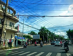
 A corner of Long Điền town A corner of Long Điền town | |
 | |
| Coordinates: 10°29′N 107°13′E / 10.483°N 107.217°E / 10.483; 107.217 | |
| Country | |
| Province | Bà Rịa–Vũng Tàu |
| District | Long Điền |
| Area | |
| • Total | 5.49 sq mi (14.21 km) |
| Population | |
| • Total | 21,632 |
| • Density | 3,940/sq mi (1,522/km) |
| Time zone | UTC+07:00 |
Long Điền is a township (Thị trấn) and town and capital of Long Điền District, Bà Rịa–Vũng Tàu province, in Vietnam.
It is located along National Route 55. It is home to the Long Ban pogoda, which was built in the 17th century.
| Bà Rịa–Vũng Tàu province | ||
|---|---|---|
| Capital: Bà Rịa | ||
| Bà Rịa |  | |
| Vũng Tàu | ||
| Phú Mỹ | ||
| Châu Đức District | ||
| Côn Đảo District |
| |
| Đất Đỏ District | ||
| Long Điền District | ||
| Xuyên Mộc District | ||
This article about a location in Bà Rịa-Vũng Tàu province, Vietnam is a stub. You can help Misplaced Pages by expanding it. |