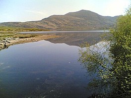
| Lough Guitane | |
|---|---|
| Loch Coiteáin (Irish) | |
 | |
 | |
| Location | County Kerry |
| Coordinates | 52°0′31″N 9°25′9″W / 52.00861°N 9.41917°W / 52.00861; -9.41917 |
| Catchment area | 19.03 km (7.3 sq mi) |
| Basin countries | Ireland |
| Max. length | 2.05 km (1.3 mi) |
| Max. width | 1.25 km (1 mi) |
| Surface area | 2.46 km (0.95 sq mi) |
| Surface elevation | 77 m (253 ft) |
| References | |
Lough Guitane (Irish: Loch Coiteáin) is a freshwater lake in the southwest of Ireland. It is located in County Kerry near the town of Killarney.
Geography
Lough Guitane measures about 2 km (1.2 mi) long and 1 km (0.6 mi) wide. The lake is about 10 km (6 mi) southeast of Killarney and to the east of Killarney National Park.
Geology
Lough Guitane is the site and namesake of a volcanic complex of tuffs and rhyolites, of which the centres are at Bennaunmore, Horses Glen and Kileen.
Natural history
Fish species in Lough Guitane include brown trout, mainly of the freshwater variety with a smaller seasonal number of the sea variety.
See also
References
- ^ "Loch Coiteáin/Lough Guitane". Placenames Database of Ireland. Government of Ireland - Department of Arts, Heritage and the Gaeltacht and Dublin City University. Retrieved 27 December 2015.
- ^ "Lough Guitane" (Map). Google Maps. Retrieved 27 December 2015.
- Free, Gary; Little, Ruth; Tierney, Deirdre; Donnelly, Karol & Caroni, Rossana (2006). A Reference Based Typology and Ecological Assessment System for Irish Lakes (PDF) (Report). Environmental Protection Agency (Ireland). p. 12. Retrieved 12 October 2022.
- New Perspectives on the Old Red Sandstone - Geological society of London. Geological Society. 2000. pp. 271–273. ISBN 9781862390713. Retrieved 24 May 2021.
- "Lough Guitane". Fáilte Ireland. Retrieved 27 December 2015.