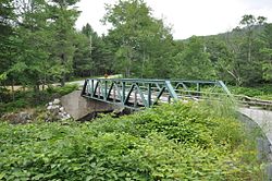
| Bridge No. 27 | |
| U.S. National Register of Historic Places | |
 | |
  | |
| Location | Town Hwy 61, Lover's Ln., Berlin, Vermont |
|---|---|
| Coordinates | 44°11′22″N 72°38′27″W / 44.18944°N 72.64083°W / 44.18944; -72.64083 |
| Area | less than one acre |
| Built | 1918 (1918) |
| Architectural style | Warren pony truss |
| MPS | Metal Truss, Masonry, and Concrete Bridges in Vermont MPS |
| NRHP reference No. | 05001523 |
| Added to NRHP | January 11, 2006 |
The Lover's Lane Bridge is a historic bridge spanning the Dog River in Berlin, Vermont. Built in 1915, it is a rare early 20th-century example of a Warren pony truss bridge. It was listed on the National Register of Historic Places in 2006 as Bridge No. 27.
Description and history
Lover's Lane is a short east-west road located in southern Berlin, joining Chandler Road to the west and Vermont Route 12 to the east, each of which run roughly parallel to the north-flowing Dog River. The bridge across the river is oriented roughly northeast-southwest, at a point where the river briefly bends to the west. It is a single-span Warren pony truss structure, 85 feet (26 m) in length, resting on modern concrete abutments. The truss elements are made of rolled steel joined by bolts, a replacement for original rivets. The bridge floor is also a modern replacement, consisting of rolled steel flange beams supporting a wooden deck.
The bridge was built about 1918, replacing an earlier wooden structure (probably an open wooden truss bridge). It was built at a time when Vermont's bridge construction, including local bridges such as this one, was becoming increasingly influenced by professional engineers hired by the state's Department of Transportation. This bridge is one of a shrinking number of structures to survive from that period.
See also
 Transport portal
 Engineering portal
National Register of Historic Places portal
- National Register of Historic Places listings in Washington County, Vermont
- List of bridges on the National Register of Historic Places in Vermont
References
- ^ "National Register Information System". National Register of Historic Places. National Park Service. July 9, 2010.
- ^ William J. Thrane, Robert McCullough (2004). "NRHP nomination for Bridge No. 27". National Park Service. Retrieved 2016-10-06. with photos from 2004
- Bridges on the National Register of Historic Places in Vermont
- National Register of Historic Places in Washington County, Vermont
- Bridges completed in 1918
- Bridges in Washington County, Vermont
- Buildings and structures in Berlin, Vermont
- Steel bridges in the United States
- Warren truss bridges in the United States
- Road bridges in Vermont
- 1918 establishments in Vermont
