| Lustleigh Cleave | |
|---|---|
 View onto Lustleigh Cleave View onto Lustleigh Cleave | |
 | |
| Length | 2 miles (3.2 km) North West-South East |
| Geography | |
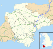
| Coordinates | 50°37′16″N 3°44′49″W / 50.621°N 3.747°W / 50.621; -3.747 |
| River | River Bovey |
The Lustleigh Cleave is a steep sided valley above the River Bovey in the parish of Lustleigh on Dartmoor. The cleave has been noted for its beauty since the 1800s, and features extensively in guidebooks.
Description
The Lustleigh Cleave is a steep-sided valley, approximately 2 miles (3.2 km) in length, with the River Bovey flowing at the bottom approximately South-Easterly.
Nothing can spoil the Cleave, where the granite, piled up like giants' castles, crowns the gorge, and is spread all the way to the stream below.
— Cresswell, 1920
The valley is scattered with granite clitter (rocks strewn across the landscape), including rocking logan stones.
Notable features
The cleave contains Hunter's Tor, a granite tor, typical of Dartmoor, and location of an Iron Age settlement, and later Domesday book settlement of Sutreworde.
There is regeneration of temperate rainforest on the Lustleigh Cleave, following a reduction in grazing and swaling.
References
- Crossing, William (1914). Guide to Dartmoor; a topographical description of the forest and the commons. Plymouth Western Morning News Co. p. 72.
- Rowe, Samuel (1898). A perambulation of the antient and royal forest of Dartmoor and the Venville precincts, or a topographical survey of their antiquities and scenery. JG Commin. p. 136.
- Nicholls Worth, Richard (1880). Tourist's guide to South Devon. London: Edward Stanford. pp. 76–77.
- A handbook for travellers in Devonshire (9th Revised ed.). London: John Murray. 1879. pp. 143–149.
- Baddeley, MJB; Ward, CS (1884). South Devon and South Cornwall. London: Dulau and Co. pp. 96–98.
- Crossing, William. Gems in a granite setting; beauties of the lone land of Dartmoor. pp. 75–79.
- Cresswell, Beatric F (1920). Dartmoor with its surroundings; a handbook for visitors. London Homeland Association. p. 34.
- Rowe, Samuel; Rowe, Joshua Brooking (1896). A perambulation of the antient and royal forest of Dartmoor and the Venville precincts, or a topographical survey of their antiquities and scenery. Exeter: JG Commin. pp. 136–137.
- "Hunter's Tor (Lustleigh)". Tors of Dartmoor.
- Mortimer, Ian (December 2021). "The Location and Extent of King Alfred's Suðewyrðe". Reports and Transactions of the Devonshire Association for the Advancement of Science. 153: 227–254.
- Shrubsole, Guy (29 April 2021). "Life finds a way: in search of England's lost, forgotten rainforests". The Guardian.
- Parker, George (16 December 2022). "In search of Britain's lost rainforests". Financial Times.
- Jones, Lucy (17 February 2023). "The plan to restore Britain's lost rainforests". Positive News.
- Shrubsole, Guy (2022). The Lost Rainforests of Britain. HarperCollins. ISBN 978-0-00-852795-2.
This Devon location article is a stub. You can help Misplaced Pages by expanding it. |
This article about a specific United Kingdom geological feature is a stub. You can help Misplaced Pages by expanding it. |