| Luzia Nunes | |
|---|---|
| Settlement | |
 | |
| Coordinates: 14°52′27″N 24°26′20″W / 14.8742°N 24.439°W / 14.8742; -24.439 | |
| Country | Cape Verde |
| Island | Fogo |
| Municipality | São Filipe |
| Civil parish | Nossa Senhora da Conceição |
| Population | |
| • Total | 438 |
| ID | 82205 |
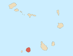
Luzia Nunes is a settlement in the southwestern part of the island of Fogo, Cape Verde. It is situated 1.5 km west of Patim, 2 km southeast of Vicente Dias and 7 km southeast of the island capital São Filipe. At the 2010 census its population was 438.
See also
References
- "2010 Census results". Instituto Nacional de Estatística Cabo Verde (in Portuguese). 24 November 2016.
| The island of Fogo | ||
|---|---|---|
| Mosteiros |  | |
| Santa Catarina do Fogo | ||
| São Filipe | ||
| Other geographical features | ||
| Transportation | ||
| Other topics | ||
This Cape Verdean location article is a stub. You can help Misplaced Pages by expanding it. |