Lighthouse
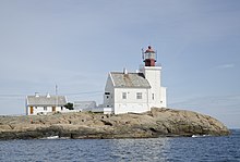
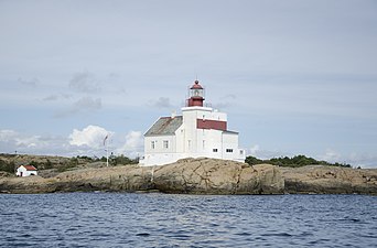
 View of the lighthouse View of the lighthouse | |
| Location | Agder, Norway |
|---|---|
| Coordinates | 58°38′09″N 9°08′54″E / 58.6359°N 09.1483°E / 58.6359; 09.1483 |
| Tower | |
| Constructed | 1879 |
| Construction | Concrete tower |
| Automated | 2004 |
| Height | 16.9 metres (55 ft) |
| Shape | Square tower |
| Markings | White with red top |
| Operator | Norsk Fyrhistorisk Forening |
| Heritage | cultural property, heritage site in Norway |
| Fog signal | None |
| Racon | None |
| Light | |
| Focal height | 21.3 metres (70 ft) |
| Lens | 3rd order Fresnel lens |
| Intensity | 59,100 cd (fixed) 616,500 cd (flash) |
| Range | 14 nmi (26 km; 16 mi) |
| Characteristic | FFl W 60s |
| Norway no. | 056600 |
Lyngør Lighthouse (Norwegian: Lyngør fyr) is a coastal lighthouse located on the island of Kjeholmen in the Lyngør area in the municipality of Tvedestrand in Agder county, Norway. Established in 1879, the lighthouse was listed as a protected site in 1997. However, it was automated in 2004, and as a result, no one is stationed there any longer.
Specifications
The Lyngør Lighthouse stands at a height of 16.9-metre (55 ft) and is characterized by its white, square, concrete tower with a red top, which is connected to a 2+1⁄2-story keeper's house. Positioned at an elevation of 21.3 metres (70 ft) above sea level, the light emits a continuous white glow, punctuated by a brighter flash once every 60 seconds. The lighthouse features an original 3rd order Fresnel lens mounted on the original rotating mechanism, with an intensity of 59,100 candela for the light and 616,500 candela for the flash. The light can be seen from all directions for up to 14 nautical miles (26 km; 16 mi). The facility is only accessible by boat, but the site is open to the public, and the keeper's house and tower are open as well, in fact, the building can be rented out for overnight accommodations.
Media gallery
See also
References
- Godal, Anne Marit (ed.). "Lyngør fyr". Store norske leksikon (in Norwegian). Oslo: Norsk nettleksikon. Retrieved 7 April 2012.
- "Lyngør fyrstasjon" (in Norwegian). Norsk Fyrhistorisk Forening. Retrieved 7 April 2012.
- Rowlett, Russ (19 July 2011). "Lighthouses of Norway: Aust-Agder (Arendal Area)". The Lighthouse Directory. University of North Carolina at Chapel Hill. Retrieved 2 January 2018.
- Kystverket (2014). Norske Fyrliste 2014 (PDF) (in Norwegian). ISBN 9788245015959. Archived from the original (PDF) on 12 June 2018. Retrieved 2 January 2018.
External links
- Norsk Fyrhistorisk Forening (in Norwegian)
This Norwegian lighthouse-related article is a stub. You can help Misplaced Pages by expanding it. |
This Agder location article is a stub. You can help Misplaced Pages by expanding it. |


