| This article includes a list of references, related reading, or external links, but its sources remain unclear because it lacks inline citations. Please help improve this article by introducing more precise citations. (September 2013) (Learn how and when to remove this message) |
| This article relies largely or entirely on a single source. Relevant discussion may be found on the talk page. Please help improve this article by introducing citations to additional sources. Find sources: "Machakhelistsqali" – news · newspapers · books · scholar · JSTOR (June 2024) |
| Machakhelistsqali | |
|---|---|
 | |
| Native name | მაჭახელისწყალი (Georgian) |
| Location | |
| Country | Georgia, Turkey |
| Physical characteristics | |
| Source | |
| • location | Artvin Province, Turkey |
| Mouth | Çoruh |
| • location | Adjara, Georgia |
| • coordinates | 41°31′07″N 41°43′08″E / 41.5186°N 41.7189°E / 41.5186; 41.7189 |
| Length | 37 km (23 mi) |
| Basin features | |
| Progression | Çoruh→ Black Sea |
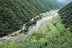
The Machakhelistsqali or Machakhlitskal (Georgian: მაჭახელისწყალი, Mač’axelisc’q’ali; Turkish: Maçahel Suyu) is a river that flows from the Artvin Province in Turkey to Adjara autonomous republic of Georgia. It's a right tributary of the Çoruh (Chorokhi).
References
- Abashidze, Irakli (1983). Georgian Soviet Encyclopedia. Vol. 6, Tb. p. 515.
This article related to a river in Turkey is a stub. You can help Misplaced Pages by expanding it. |
This article about a Black Sea Region of Turkey location is a stub. You can help Misplaced Pages by expanding it. |
This article related to a river in Georgia is a stub. You can help Misplaced Pages by expanding it. |