| Madhyabindu मध्यबिन्दु नगरपालिका | |
|---|---|
| Municipality | |
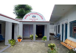
 Madhyabinhu municipality office building Madhyabinhu municipality office building | |
  | |
| Coordinates: 27°21′N 84°00′E / 27.35°N 84.0°E / 27.35; 84.0 | |
| Country | |
| Zone | Lumbini |
| District | Nawalpur |
| Government | |
| • Mayor | Chandra Bahadur Rana (NC) |
| • Deputy Mayor | Om Kumari Mahato (NC) |
| Area | |
| • Total | 69.8 km (26.9 sq mi) |
| Population | |
| • Total | 28,224 |
| • Density | 400/km (1,000/sq mi) |
| Time zone | UTC+5:45 (NST) |
| Area code | 078 |
| Website | http://madhyabindumun.gov.np |
Madhyabindu is a municipality of Nawalpur District in Lumbini Zone of southern Nepal. The municipality was established on 19 September 2015 by merging the existing Tamasariya, Naya Belahani and Kolhuwa village development committees (VDCs). The center of the municipality is established in the former Tamasariya VDC of Chormara Bazaar. After merging the three VDCs population it had a total population of 28,224 according to 2011 Nepal census. After the government decision the number of Sub Metropolitan cities and municipalities has reached 12 and 217 respectively in Nepal.
Chormara Bajar Chormara Bajar is located at the mid-point East-West Mahendra highway. it is one of the oldest residential areas in the Nawalparasi district. Arunkhola is the largest bazaar of Madhyabindu located at Madhyabindu ward no 10. One of the oldest Brewery companies in Nepal Shree Distillery Pvt ltd is also situated at Arunkhola Bazar. Most of the area's forest is part of Chitwan National Park. it was established in 1973 and was granted the status of a World Heritage Site in 1984. The municipality shares the border with India to the south, and which Narayani river separates the nations.
References
- "Govt declares 26 new municipalities". EKantipur. 19 September 2015.
- "26 new Municipalities announced". The Rising Nepal. Retrieved 2015-09-18.
- "Govt announces 26 municipalities" (PDF). The Kathmandu Post. Archived from the original (PDF) on 2015-10-01. Retrieved 2015-09-18.
- Central Bureau of Statistics of Nepal: National Population and Housing Census 2011 Archived 2013-09-27 at the Wayback Machine
- "Govt adds 26 municipalities, 1 sub metropolis". Setopati. Archived from the original on 20 September 2015. Retrieved 18 September 2015.
External links
| Nawalpur District | ||
|---|---|---|
| Headquarters: Kawasoti | ||
| Urban municipalities: 4 |  | |
| Rural municipalities: 4 | ||
This article about a location in the Nawalpur District of Nepal is a stub. You can help Misplaced Pages by expanding it. |