| Mammendorf | |
|---|---|
| Municipality | |
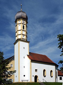
 Church of Saint Peter and Paul in Nannhofen Church of Saint Peter and Paul in Nannhofen | |
 Coat of arms Coat of arms | |
Location of Mammendorf within Fürstenfeldbruck district
 | |
  | |
| Coordinates: 48°12′N 11°11′E / 48.200°N 11.183°E / 48.200; 11.183 | |
| Country | Germany |
| State | Bavaria |
| Admin. region | Oberbayern |
| District | Fürstenfeldbruck |
| Government | |
| • Mayor (2020–26) | Josef Heckl |
| Area | |
| • Total | 21.21 km (8.19 sq mi) |
| Elevation | 536 m (1,759 ft) |
| Population | |
| • Total | 5,047 |
| • Density | 240/km (620/sq mi) |
| Time zone | UTC+01:00 (CET) |
| • Summer (DST) | UTC+02:00 (CEST) |
| Postal codes | 82291 |
| Dialling codes | 08145 |
| Vehicle registration | FFB |
| Website | www.mamendorf.de |
Mammendorf is a municipality in Bavaria, Germany. It is located halfway between Munich and Augsburg.
Location
Mammendorf is part of the district of Fürstenfeldbruck, Upper Bavaria and lies about 6 kilometres northwest of the city of Fürstenfeldbruck. The towns Nannhofen and Peretshofen are part of the municipality of Mammendorf.
Geography
The Maisach River flows through Mammendorf.
Transport
Mammendorf-Nannhofen is the last station of the Munich S-Bahn line S3, as well as the terminus of the R1 line of Augsburg's transport system, Augsburger Verkehrsverbund (AVV).
Notable people
- Gerhard Merz, artist
References
- Liste der ersten Bürgermeister/Oberbürgermeister in kreisangehörigen Gemeinden, Bayerisches Landesamt für Statistik, 15 July 2021.
- Genesis Online-Datenbank des Bayerischen Landesamtes für Statistik Tabelle 12411-003r Fortschreibung des Bevölkerungsstandes: Gemeinden, Stichtag (Einwohnerzahlen auf Grundlage des Zensus 2011).
| Towns and municipalities in Fürstenfeldbruck district | ||
|---|---|---|
This Fürstenfeldbruck district location article is a stub. You can help Misplaced Pages by expanding it. |