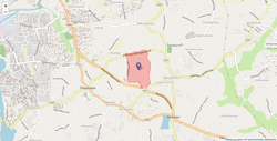
| Mampe East | |
|---|---|
| Grama Niladhari Division | |
 Mampe East Grama Niladhari Division Mampe East Grama Niladhari Division | |
| Coordinates: 6°48′20″N 79°56′00″E / 6.805470°N 79.933430°E / 6.805470; 79.933430 | |
| Country | Sri Lanka |
| Province | Western Province |
| District | Colombo District |
| Divisional Secretariat | Kesbewa Divisional Secretariat |
| Electoral District | Colombo Electoral District |
| Polling Division | Kesbewa Polling Division |
| Area | |
| • Total | 0.44 km (0.17 sq mi) |
| Elevation | 26 m (85 ft) |
| Population | |
| • Total | 2,040 |
| • Density | 4,636/km (12,010/sq mi) |
| ISO 3166 code | LK-1136210 |
Mampe East Grama Niladhari Division is a Grama Niladhari Division of the Kesbewa Divisional Secretariat of Colombo District of Western Province, Sri Lanka . It has Grama Niladhari Division Code 574D.
Mampe East is a surrounded by the Mavittara South, Kesbewa North, Mampe West, Vishwakalawa, Mampe North and Mavittara North Grama Niladhari Divisions.
Demographics
Ethnicity
The Mampe East Grama Niladhari Division has a Sinhalese majority (98.8%) . In comparison, the Kesbewa Divisional Secretariat (which contains the Mampe East Grama Niladhari Division) has a Sinhalese majority (97.3%)
Ethnicity in Mampe East
Sinhalese (98.8%) Other (1.2%)Religion
The Mampe East Grama Niladhari Division has a Buddhist majority (94.6%) . In comparison, the Kesbewa Divisional Secretariat (which contains the Mampe East Grama Niladhari Division) has a Buddhist majority (93.0%)
Religion in Mampe East
Buddhist (94.6%) Roman Catholic (3.2%) Other Christian (1.7%) Other (0.5%)| Places adjacent to Mampe East Grama Niladhari Division | ||||||||||||||||
|---|---|---|---|---|---|---|---|---|---|---|---|---|---|---|---|---|
| ||||||||||||||||
References
- "USGS EarthExplorer". earthexplorer.usgs.gov. U.S. Geological Survey. 2020.
- ^ "Census of Population and Housing 2012". statistics.gov.lk. Department of Census and Statistics, Sri Lanka. 2012.
This Sri Lanka–related article is a stub. You can help Misplaced Pages by expanding it. |