| Manakambahiny Ankavia | |
|---|---|
 | |
| Coordinates: 15°14′S 50°04′E / 15.233°S 50.067°E / -15.233; 50.067 | |
| Country | |
| Region | Sava |
| District | Antalaha |
| Population | |
| • Total | 7,830 |
| Time zone | UTC3 (EAT) |
| Postal code | 206 |
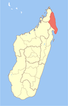
Manakambahiny Ankavia is a rural municipality in northern Madagascar. It belongs to the district of Antalaha, which is a part of Sava Region. The municipality has a populations of 7,830 inhabitants (2019).
Agriculture
The agriculture is mainly substancial: rice, manioc, banana, sugar cane, next to vanilla, cloves and coffee are planted.
Tourism
It is situated at the border of the Masoala National Park on the river Ankavia.
References
- mapcarta.com/fr/N8524241482 mapcarta.com
| Capital: Sambava | ||
| Andapa (17) |  | |
| Antalaha (14) | ||
| Sambava (25) | ||
| Vohemar (19) | ||
| 4 districts; 75 communes | ||
This Sava region of Madagascar location article is a stub. You can help Misplaced Pages by expanding it. |