Tehsil in Jammu and Kashmir, India
| Mandi | |
|---|---|
| Tehsil | |
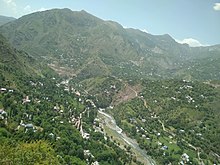
 A view of Mandi from the Western Hills A view of Mandi from the Western Hills | |
  | |
| Coordinates: 33°47′46″N 74°15′14″E / 33.79611°N 74.25389°E / 33.79611; 74.25389 | |
| Country | |
| Union Territory | |
| District | Poonch |
| Headquarters | Mandi |
| Government | |
| • Type | Tehsil |
| • Body | Tehsildar |
| Population | |
| • Total | 77,947 |
| Languages | |
| • Official | Dogri, English, Hindi, Kashmiri, Urdu |
| • Spoken | Gojri, Kashmiri, Pahari |
| Time zone | UTC+5:30 (IST) |
| PIN | 185102 |
| Telephone code | 01965 |
| Vehicle registration | JK-12 |
| Literacy | 58.28% |
| Website | www |

Mandi is a town and a tehsil in the Poonch district of the Indian union territory of Jammu and Kashmir. Mandi is located in east of the Poonch district, about 171 kilometres (106 mi) from Srinagar and 1 kilometre (0.62 mi) south of the Line of Control with Pakistan. The Ancient Hindu temple Baba Budha Amernath is located here.
Demographics
Religion in Mandi Tehsil (2011)
Islam (96.14%) Hinduism (2.94%) Sikhism (0.43%) Christianity (0.15%) Buddhism (0.01%) Not Stated (0.34%)The total projected population of Mandi Tehsil is 77,947, with 41,365 males and 36,582 females according to the 2011 census of India. The population includes Gujjars, Bakerwals, Pahari-Pothwari Speakers, which is intermediate between Lahnda and Punjabi. and Kashmiris.
Transportation
Air
Poonch Airport is a non-operational airstrip in the district headquarters Poonch. The nearest airport to Mandi is Sheikh ul-Alam International Airport in Srinagar, located 180 kilometres from Mandi.
Rail
There is no railway connectivity to Mandi. There are plans to construct a Jammu–Poonch line which will connect Jammu with Poonch with railways. The nearest major railway station is Jammu Tawi railway station located 240 kilometres from Mandi.
Road
The tehsil is connected to other places in Jammu and Kashmir and India by the NH 144A and other intra-district roads.
See also
References
- "Administrative Setup in District Poonch". Poonch District. Retrieved 15 September 2019.
- "Mandi Tehsil Population". Census India. Retrieved 10 July 2021.
- Lothers & Lothers 2010, p. 2.
- Shackle 1979, p. 201.
Works cited
- Lothers, Michael; Lothers, Laura (2010). Pahari and Pothwari: a sociolinguistic survey (Report). SIL Electronic Survey Reports. Vol. 2010–012.
- Shackle, Christopher (1979). "Problems of classification in Pakistan Panjab". Transactions of the Philological Society. 77 (1): 191–210. doi:10.1111/j.1467-968X.1979.tb00857.x. ISSN 0079-1636.
| Poonch District, India | |||||||||||||
|---|---|---|---|---|---|---|---|---|---|---|---|---|---|
| Cities and Towns | |||||||||||||
| Tehsils and villages |
| ||||||||||||
This article related to a location in Jammu and Kashmir is a stub. You can help Misplaced Pages by expanding it. |