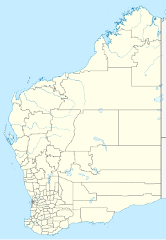
Mandora Station is a cattle station on the Western Australia coast south of Broome, located in the Shire of Broome. In earlier years it has also been a sheep station.
It maintains a weather station and is noted for the Mandora Marsh wetland, and for its proximity to Eighty Mile Beach, which are key stopping places for migratory birds.
Mandora crater on Mars is named after the locality; the name of the Mandurah suburb of Madora Bay was also derived from that of the station.
In 2017 the property was sold by Peter and Pol Edmunds. The Edmunds are relatives of the De Pledge family who had owned the property since the 1940s. The 94,000-hectare (232,279-acre) property stocked with 4,500 head of droughtmaster cattle was bought by the Sale family who also have an interest in Bulka, Yougawalla, and Margaret River Stations.
Climate
| Climate data for Mandora, Western Australia | |||||||||||||
|---|---|---|---|---|---|---|---|---|---|---|---|---|---|
| Month | Jan | Feb | Mar | Apr | May | Jun | Jul | Aug | Sep | Oct | Nov | Dec | Year |
| Record high °C (°F) | 46.8 (116.2) |
46.7 (116.1) |
45.6 (114.1) |
43.6 (110.5) |
39.8 (103.6) |
36.6 (97.9) |
36.1 (97.0) |
39.6 (103.3) |
42.8 (109.0) |
46.8 (116.2) |
46.5 (115.7) |
48.4 (119.1) |
48.4 (119.1) |
| Mean daily maximum °C (°F) | 36.0 (96.8) |
35.6 (96.1) |
36.9 (98.4) |
36.2 (97.2) |
32.1 (89.8) |
29.1 (84.4) |
29.0 (84.2) |
30.9 (87.6) |
33.8 (92.8) |
36.0 (96.8) |
36.6 (97.9) |
36.7 (98.1) |
34.1 (93.4) |
| Mean daily minimum °C (°F) | 25.4 (77.7) |
24.9 (76.8) |
24.0 (75.2) |
20.8 (69.4) |
16.9 (62.4) |
14.1 (57.4) |
12.5 (54.5) |
13.2 (55.8) |
15.7 (60.3) |
19.2 (66.6) |
21.9 (71.4) |
24.5 (76.1) |
19.4 (66.9) |
| Record low °C (°F) | 18.8 (65.8) |
15.6 (60.1) |
14.5 (58.1) |
11.0 (51.8) |
5.7 (42.3) |
3.4 (38.1) |
−0.6 (30.9) |
1.4 (34.5) |
5.4 (41.7) |
10.0 (50.0) |
12.8 (55.0) |
14.5 (58.1) |
−0.6 (30.9) |
| Average precipitation mm (inches) | 87.6 (3.45) |
105.2 (4.14) |
73.7 (2.90) |
19.1 (0.75) |
24.8 (0.98) |
17.3 (0.68) |
8.8 (0.35) |
2.5 (0.10) |
1.0 (0.04) |
1.2 (0.05) |
6.4 (0.25) |
33.9 (1.33) |
376.6 (14.83) |
| Average rainy days | 4.6 | 4.9 | 3.4 | 1.0 | 1.3 | 1.0 | 0.7 | 0.3 | 0.1 | 0.1 | 0.3 | 1.9 | 19.6 |
| Source: | |||||||||||||
See also
Notes
- "Rams for Pastoral Areas". Western Mail. Perth, Western Australia: National Library of Australia. 22 May 1941. p. 37. Retrieved 22 January 2012.
- Matt Brann (13 January 2017). "De Pledge family sells Mandora cattle station south of Broome". Australian Broadcasting Corporation. Retrieved 18 March 2017.
- "Climate Statistics for Mandora". Australian Bureau of Meteorology. Retrieved 7 June 2018.
External links
19°44′31.66″S 120°50′37.95″E / 19.7421278°S 120.8438750°E / -19.7421278; 120.8438750
This article about a location in Western Australia is a stub. You can help Misplaced Pages by expanding it. |