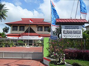
| Manggar Baru Kelurahan Manggar Baru | |
|---|---|
| Subdistrict | |
  (From the top: Manggar Segarasari Beach
 bottom: Office government Manggar Baru subdistrict) | |
 | |
| Interactive map of Manggar Baru subdistrict | |
| Coordinates: 1°13′04″S 116°58′03″E / 1.217846°S 116.967402°E / -1.217846; 116.967402 | |
| Country | |
| Province | East Kalimantan |
| City | Balikpapan |
| District | East Balikpapan |
| Area | |
| • Total | 3.836 km (1.481 sq mi) |
| Time zone | GMT +8 |
Manggar Baru is a subdistrict in the East Balikpapan, Balikpapan. On August 16, 2013, Manggar Baru became one of the representatives of East Kalimantan who participated in the "Best Subdistrict at the National", then passed the verification stage from the national assessment team and made it into the top six subsidtrict national held in Jakarta.
Tourisms
- Manggar Segarasari Beach (Pantai Manggar Segarasari)
References
- Balikpapan, Official Government (2011-12-07). "Wilayah Administrasi Kota Balikpapan" (in Indonesian).
- Balikpapan, Official Government. "Keadaan Geografi dan Demografi". balikpapantimur.balikpapan.go.id. Retrieved 2021-03-01.
- East Kalimantan, Humas (2013-08-16). "Lomba Kelurahan dan Desa Terbaik Tingkat Nasional 2013". East Kalimantan official website.
External links
| Balikpapan, East Kalimantan | ||
|---|---|---|
| Districts (Subdistricts) | ||
| Landmarks | ||
| Related topics | ||
This East Kalimantan location article is a stub. You can help Misplaced Pages by expanding it. |