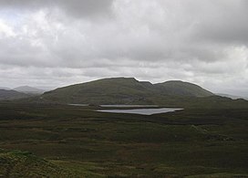
| Manod Mawr | |
|---|---|
 Manod Mawr North Top and Manod Mawr from Moel Penamnen Manod Mawr North Top and Manod Mawr from Moel Penamnen | |
| Highest point | |
| Elevation | 661 m (2,169 ft) |
| Prominence | 266 m (873 ft) |
| Parent peak | Arenig Fach |
| Listing | Marilyn, Hewitt, Nuttall |
| Naming | |
| English translation | great snowdrift |
| Language of name | Welsh |
| Pronunciation | Welsh: [ˈmanɔd ˈmaur] |
| Geography | |
| Location | Gwynedd, Wales |
| Parent range | Moelwynion |
| OS grid | SH723446 |
| Topo map | OS Landranger 124 |
| Name | Grid ref | Height | Status |
|---|---|---|---|
| Manod Mawr North Top | 658 m (2,159 ft) | Hewitt, Nuttall | |
| Moel Penamnen | 623 m (2,044 ft) | Hewitt, Nuttall |
Manod Mawr is a mountain in North Wales and forms part of the Moelwynion. Although known as a mountain in the eastern Moelwyns, it and its sister peaks are sometimes known as the Ffestiniog hills.
Manod Mawr is a mountain which has been extensively quarried. The now-closed Graig Ddu Quarry is to be found on the 600-metre (2,000 ft) contour, in the hollow between Manod Mawr's summit and Manod Mawr North Top. Manod Mawr's summit is in the exclusion zone of the Snowdonia National Park around Blaenau Ffestiniog, while Manod Mawr North Top's summit only just misses out on the national park's protection. There were fears the quarry would eventually remove the North Top.
During the Second World War, quarry tunnels in the Manod range were used to store and protect, in secret, valuable paintings from the National Gallery in London.
References
- Nuttall, John & Anne (1999). The Mountains of England & Wales - Volume 1: Wales (2nd edition ed.). Milnthorpe, Cumbria: Cicerone. ISBN 1-85284-304-7.
- "Manod Mawr paintings". Daily Post. Retrieved 20 December 2018.
- Shenton, Caroline (2021). National Treasures: Saving the Nation’s Art in World War II (Hardback). London: John Murray. pp. 215–222, 224–232, 251–252. ISBN 978-1-529-38743-8.
External links
52°59′01″N 3°54′13″W / 52.98348°N 3.90360°W / 52.98348; -3.90360
This Gwynedd location article is a stub. You can help Misplaced Pages by expanding it. |