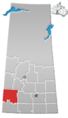
Special service area in Saskatchewan, Canada
| Mantario | |
|---|---|
| Special service area | |
| Special Service Area of Mantario | |
  | |
| Coordinates: 51°15′44″N 109°41′57″W / 51.2623°N 109.6991°W / 51.2623; -109.6991 | |
| Country | Canada |
| Province | Saskatchewan |
| Region | Saskatchewan |
| Census division | 8 |
| Rural Municipality | Chesterfield No. 261 |
| Post office founded | March 1, 1912 (closed March 27, 1986) |
| Incorporated (village) | N/A |
| Incorporated (town) | N/A |
| Government | |
| • Reeve | Karrie Derouin |
| • Administrator | Beverly Dahl |
| • Governing body | Chesterfield No. 261 |
| Area | |
| • Total | 0.78 km (0.30 sq mi) |
| Population | |
| • Total | 5 |
| • Density | 6.4/km (16.6/sq mi) |
| Time zone | CST |
| Postal code | S0L 2J0 |
| Area code | 306 |
| Highways | Highway 44 |
Mantario is a special service area in the Rural Municipality of Chesterfield No. 261 in the Canadian province of Saskatchewan.It held village status prior to June 30, 2007. The population was five people in 2011. The community is located 70 kilometres (43 mi) southwest of the town of Kindersley on Highway 44.
Mantario is a portmanteau of Manitoba and Ontario. It was named after two provinces in imitation of nearby Alsask.
Demographics
In the 2021 Census of Population conducted by Statistics Canada, Mantario had a population of 15 living in 5 of its 7 total private dwellings, a change of 200% from its 2016 population of 5. With a land area of 0.77 km (0.30 sq mi), it had a population density of 19.5/km (50.5/sq mi) in 2021.
Canada census – Mantario community profile| 2011 | |
|---|---|
| Population | 5 (-50.0% from 2006) |
| Land area | 0.78 km (0.30 sq mi) |
| Population density | 6.4/km (17/sq mi) |
| Median age | NA (M: NA, F: NA) |
| Private dwellings | 9 (total) |
| Median household income | $NA |
See also
- List of communities in Saskatchewan
- List of hamlets in Saskatchewan
- List of geographic names derived from portmanteaus
References
- National Archives, Archivia Net, Post Offices and Postmasters, archived from the original on October 6, 2006, retrieved August 1, 2011
- Government of Saskatchewan, MRD Home, Municipal Directory System, archived from the original on November 21, 2008
- Canadian Textiles Institute. (2005), CTI Determine your provincial constituency, archived from the original on September 11, 2007
- Commissioner of Canada Elections, Chief Electoral Officer of Canada (2005), Elections Canada On-line, archived from the original on April 21, 2007
- "Municipal Directory System" (PDF). Government of Saskatchewan. p. 228. Retrieved November 19, 2016.
- "Restructured Villages". Saskatchewan Ministry of Municipal Affairs. Archived from the original on March 25, 2008. Retrieved February 10, 2008.
- Barry, Bill (September 2005). Geographic Names of Saskatchewan. Regina, Saskatchewan: People Places Publishing, Ltd. p. 271. ISBN 1-897010-19-2.
- "Population and dwelling counts: Canada and designated places". Statistics Canada. February 9, 2022. Retrieved August 31, 2022.
- "2011 Community Profiles". 2011 Canadian census. Statistics Canada. March 21, 2019.
- "2006 Community Profiles". 2006 Canadian census. Statistics Canada. August 20, 2019.
- "2001 Community Profiles". 2001 Canadian census. Statistics Canada. July 18, 2021.
| Places adjacent to Mantario | ||||||||||||||||
|---|---|---|---|---|---|---|---|---|---|---|---|---|---|---|---|---|
| ||||||||||||||||
51°15′44″N 109°41′57″W / 51.2623°N 109.6991°W / 51.2623; -109.6991
This article about a location in the Census Division No. 8 of Saskatchewan is a stub. You can help Misplaced Pages by expanding it. |
