Unincorporated community in South Carolina, United States
| Mars Bluff, South Carolina | |
|---|---|
| Unincorporated community | |
  | |
| Coordinates: 34°12′20″N 79°39′19″W / 34.20556°N 79.65528°W / 34.20556; -79.65528 | |
| Country | United States |
| State | South Carolina |
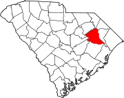
| County | Florence County |
| Elevation | 98 ft (30 m) |
| Time zone | UTC-5 (Eastern (EST)) |
| • Summer (DST) | UTC-4 (EDT) |
| ZIP code | 29506 |
| Area code(s) | 843, 854 |
| GNIS feature ID | 1246538 |
Mars Bluff is an unincorporated community in Florence County, South Carolina, United States that bears the distinction of having been inadvertently bombed with a nuclear weapon by the United States Air Force.
History
Originally known as Marr's Bluff during the American Revolution, the area west of the Great Pee Dee River eventually became known as Mars Bluff at some point before the American Civil War. Near the end of the American Civil War, the Mars Bluff Naval Yard was established, one of many inland Confederate naval yards.
Nuclear bomb accident
Main article: 1958 Mars Bluff B-47 nuclear weapon loss incident
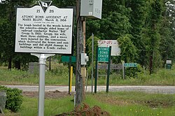
On March 11, 1958 a U.S. Air Force B-47 Stratojet with a nuclear payload, which did not have its fissile nuclear core installed at the time of the accident, left for nuclear training exercises for war preparations in the United Kingdom and South Africa. While attempting to secure the weapon after a warning light went on in the cabin, the navigator mistakenly caused it to be released, and it crashed onto the bomb bay doors, opening them and continuing downward. Although the bomb was not armed with its nuclear core (which was stored separately on the plane), it contained several tons of high explosives. Upon impacting with the ground, these high explosives detonated caused a large explosion, creating a crater estimated to be 75 feet (23 m) wide and 25–35 feet (7.6–10.7 m) deep. It landed approximately 50 yards from the house and garage of Walter Gregg. The blast injured Gregg, his wife, his three children, and his niece. It destroyed his house, damaged several other nearby houses and a church, and killed Gregg's chickens. The site is located near US 301, but is difficult to access due to the site being on private property. Fragments of the bomb are on display at Florence County Museum.
References
- ^ "Mars Bluff, South Carolina". Geographic Names Information System. United States Geological Survey, United States Department of the Interior. Retrieved November 12, 2013.
- Reynolds, William (2012). Andrew Pickens: South Carolina patriot in the Revolutionary War. McFarland & Company, Inc. ISBN 978-0-7864-6694-8.
- "Mars Bluff and the CSS Pee Dee". Dixie Historical Society. June 11, 2009. Archived from the original on November 13, 2013. Retrieved November 12, 2013.
- Jackson, Gavin (July 25, 2013). "Accidental Mars Bluff bombing survivor dies at 92". The Morning News. Florence, South Carolina.
- "Atom Bomb Dropped Here". RoadsideAmerica.com.
- "Mars Bluff Bomb". Florence County Museum.
External links
- "Dead" A-Bomb Hits US Town, Universal Newsreel story, Internet Archive
- Only Atomic Bomb Ever Dropped on America Archived August 20, 2014, at Wikiwix, The HistoryPodcast 1
| Municipalities and communities of Florence County, South Carolina, United States | ||
|---|---|---|
| County seat: Florence | ||
| Cities |  | |
| Towns | ||
| CDPs | ||
| Other communities | ||