| Maskelyne Islands | |
|---|---|
| Archipelago | |
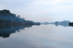
 Maskelynes anchorage Maskelynes anchorage | |
 Location of Malakula within Vanuatu Location of Malakula within Vanuatu | |
| Coordinates: 16°30′S 167°50′E / 16.500°S 167.833°E / -16.500; 167.833 | |
| Country | |
| Province | Malampa Province |
| Population | |
| • Total | 1,022 |
| Time zone | UTC+11 (VUT) |
The Maskelyne Islands, often abbreviated as the Maskelynes, are a small chain of low islands that forms part of Vanuatu in the Pacific Ocean. Among the islands are Awei, Avock, Leumanang, Uluveo, and Vulai. Uluveo (also called Maskelyne) is the main island in the group and has three villages.
The islands lie at the southeastern end of Malakula, which is the second-largest island in the nation of Vanuatu. They were named by Captain Cook after the Astronomer Royal Nevil Maskelyne as he sailed north from Port Resolution on Tanna in HMS Resolution in late 1774.
Population
The Maskelyne islands are relatively well-inhabited, (1,022 by 2009). which is considered to have historical reasons in part that life on the islands provided protection from attacks by mainland tribes which were not good seafarers, and thus had trouble reaching the island chain. However, the island chain also went through a variety of cycles of population and depopulation (causes not given in reference).
Economy and services
The area is rich with fish and sharks, and Lonely Planet describes the Maskelynes as 'just gorgeous' and recommends them for snorkelling and diving opportunities—though warning of strong currents between the islands. However, as of the late 2000s, there was little tourism in the area, being a very remote part of Vanuatu.
The islands have very little modern infrastructure, even for the local Pacific island environment, though the Vanuatu government and various aid agencies have cooperated with locals to assist some smaller local schools and health facilities.
References
- "The Maskelyne Islands, South Malekula". Positive Earth. Retrieved 10 August 2018.
- "A Cruising Sailor Gets Up Close and Personal". Cruising World. 11 May 2007. Retrieved 3 December 2011.
- 2009 Census Summary release final Archived 2013-12-21 at the Wayback Machine - Government of Vanuatu
- Speiser, Felix (1923). Ethnology of Vanuatu (translation of "Ethnographische Materialien aus den Neuen Hebriden und den Banks Inseln").
- Bob Bowdey; Judy Beaty; Brian Ansell (1995). Diving and snorkeling guide to Vanuatu.
- "Introducing The Maskelynes". Lonely Planet. 1 October 2008. Retrieved 3 December 2011.
- ^ "Where They Went: Vanuatu". Boston.com. 13 March 2005. Archived from the original on 6 June 2012. Retrieved 3 December 2011.
External links
- The Maskelyne Islands, South Malekula (a website describing some of the facilities for visitors)
| Islands of Vanuatu by province | |||||||||||||
|---|---|---|---|---|---|---|---|---|---|---|---|---|---|
| Provinces of Vanuatu |  | ||||||||||||
| Islands and islets |
| ||||||||||||
This Vanuatu location article is a stub. You can help Misplaced Pages by expanding it. |