| Mat | |
|---|---|
 Shkopet reservoir Shkopet reservoir | |
| Location | |
| Country | Albania |
| Physical characteristics | |
| Mouth | Adriatic Sea |
| • coordinates | 41°38′12″N 19°34′17″E / 41.63667°N 19.57139°E / 41.63667; 19.57139 |
| • elevation | 0 m (0 ft) |
| Length | 115 km (71 mi) |
| Basin size | 2,441 km (942 sq mi) |
| Discharge | |
| • average | 103 m/s (3,600 cu ft/s) |
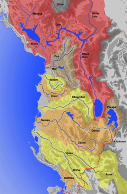
The Mat (Albanian definite form: Mati) is a river in north-central Albania. Its overall length is 115 km (71 mi), while its catchment surface is 2,441 km (942 sq mi). Its average discharge is 103 m/s (3,600 cu ft/s). The main tributary is the Fan, flowing from the northeast, while the Mat flows from the southwest down to the confluence with Fan and then towards the Adriatic Sea.
Etymology
The Albanian name mat originally meant "elevated location", "mountain place". Today's meaning in Albanian, "river bank, river shore", is a consequence of a secondary change through the common use of both the terms mal, "mountain" and breg, "shore", giving the meaning of "elevation". The river was recorded by Roman writer Vibius Sequester (4th or 5th century AD) as Mathis, following a hellenized graphic mode of the term mat. It appeared in written records also as Mathia in 1380.
Overview
See also: Mat (region)
The Mat originates from the confluence of several streams within the karstic mountains in Martanesh, where it forms deep gorges and canyons. Rising in Martanesh, the Mat heads westwards to the town of Klos and then northwest by the town of Burrel. About 10 km (6 mi) downstream from Burrel, it flows into lake Ulëz. After passing through the Ulëz dam, it flows through another lake, Shkopet, dammed again by the Shkopet Hydroelectric Power Station forming a narrow gorge through the mountain range that separates Mat from the coastal plains. It enters the plains between Milot and Zejmen.
After a total length of 115 km (71 mi), the Mat flows into the Adriatic Sea near Fushë-Kuqe, between the towns of Lezhë and Laç.
Gallery
See also
- Mat (region)
- Mat (municipality)
- Klos (municipality)
- Burrel
- Geography of Albania
- Central Mountain Range
- List of rivers of Albania
Sources
Citations
- INSTAT (2007). Tregues Sipas Qarqeve / Indicators by Prefectures, 2005-2006 (PDF) (in Albanian and English). Tiranë: INSTAT. Archived from the original (PDF) on 2011-07-24. Retrieved 2012-11-02.
- Ministry of Public Works and Transport (May 2013). Albania Water Sector Investment Project PHRD Grant No TF093096-AL Consultant Services for Preparation of the Environmental Impact Assessment and Environmental Management Plan (PDF) (Report). Tirana. p. 40. Archived from the original (PDF) on 2015-04-30. Retrieved 2017-09-23 – via dpuk.gov.al.
- "Mati River Basin Management Plan" (PDF). ibeca.al. 15 September 2010. p. 17. Archived from the original (PDF) on 24 September 2017. Retrieved 23 September 2017.
- Cullaj, A.; Hasko, A.; Miho, A.; Schanz, F.; Brandl, H.; Bachofen, R. (2005). "The quality of Albanian natural waters and the human impact". Environment International. 31 (1): 138. doi:10.1016/j.envint.2004.06.008. PMID 15607787.
- Matzinger 2009, p. 34.
- Elsie 2010, p. 295.
- Bollobani (Dodoveci), Elvira (2016). Veçoritë fiziko – gjeografike dhe potenciali ekonomik i zonës Çermenikë – Gollobordë – Martanesh (PDF) (Doctoral thesis) (in Albanian). Universiteti i Tiranës. p. 89. Archived from the original (PDF) on 2017-10-27.
- Eftimi, R. (2003). "Some Considerations on Seawater-Freshwater Relationship in Albanian Coastal Area" (PDF). In López-Geta, Juan Antonio; de Dios Gómez, Juan; de la Orden, José Antonio; Ramos, Gerardo; Rodriguez, Luis (eds.). Tecnología de la intrusión de agua de mar en acuíferos costeros: Países mediterráneos: Estado de la intrusión de agua de mar en los acuíferos costeros del Mediterráneo y técnicas de evaluación / Coastal Aquifers Intrusion Technology: Mediterranean Countries: The Sete of Sea Water Intrusion in Coastal Aquifers of the Mediterranean and Assessment Techniques / Technologie de l'intrusion d'eau de mer dans les nappes aquiferes côtières: Pays méditerranéens: Situation d l'intrusion d'eau de mer dans les nappes aquifères côtières de la Mediterranée et technique d́évaluation. Vol. 2. Madrid: Instituto Geológico y Minero de España. pp. 239–250. ISBN 84-7840-471-6.
Bibliography
- Elsie, Robert (2010). Historical Dictionary of Albania (PDF). Historical Dictionaries of Europe. Vol. 75 (2nd ed.). Scarecrow Press. p. 255. ISBN 978-0-8108-6188-6. Archived from the original (PDF) on 6 October 2014.
- Matzinger, Joachim (2009). "Shqiptarët si pasardhës të ilirëve nga këndvështrimi i gjuhësisë historike". In Schmitt, Oliver Jens; Frantz, Eva Anne (eds.). Historia e Shqiptarëve: Gjendja dhe perspektivat e studimeve (in Albanian). Translated by Pandeli Pani and Artan Puto. Botime Përpjekja. ISBN 978-99943-0-254-3.
| Rivers in Albania | |
|---|---|

