| This article includes a list of general references, but it lacks sufficient corresponding inline citations. Please help to improve this article by introducing more precise citations. (February 2018) (Learn how and when to remove this message) |

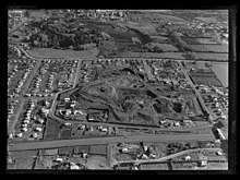
McLennan Hills (also Te Aponga o Tainui) is one of the volcanoes in the Auckland volcanic field. It was a group of cratered scoria mounds up to 45 m high, before it was quarried away. A 1940 aerial photo (in Searle's book) shows a crater around 100 m wide, one around 50 m wide, and 2 or 3 smaller craters. McLennan Hills, alongside neighbouring Ōtāhuhu / Mount Richmond, were the sites of fortified pā in pre-European times, important due to their location between the Waitematā Harbour/Tāmaki River and the Manukau Harbour. Since the European settlement of Auckland, the scoria cone was quarried. The former quarry site was used for greenhouses before being redeveloped for housing.
References
- City of Volcanoes: A geology of Auckland - Searle, Ernest J.; revised by Mayhill, R.D.; Longman Paul, 1981. First published 1964. ISBN 0-582-71784-1.
- Volcanoes of Auckland: A Field Guide. Hayward, B.W.; Auckland University Press, 2019, 335 pp. ISBN 0-582-71784-1.
References
- ^ Furey, Louise (1986). "The Excavation of Westfield (R11/898), South Auckland". Records of the Auckland Institute and Museum. 23: 1–24. ISSN 0067-0464. JSTOR 42906356. Wikidata Q58677261.
External links
- View south from Mt Wellington in 1920, showing McLennan Hills in distance.
- 1940s aerial photo of Mclennan Hills.
- Painting of McLennan Hills from the tuff ring crest of Mt Richmond in 1861.
36°55′45″S 174°50′47″E / 36.929208°S 174.846468°E / -36.929208; 174.846468
This Auckland Region-related geography article is a stub. You can help Misplaced Pages by expanding it. |
