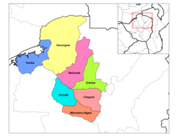
Second-level administrative subdivision in Mashonaland West, Zimbabwe
| Mhondoro-Ngezi District | |
|---|---|
| Second-level administrative subdivision | |
 | |
| Country | Zimbabwe |
| Province | Mashonaland West |
| Area | |
| • Total | 4,295 km (1,658 sq mi) |
| Population | |
| • Total | 140,994 |
| • Density | 33/km (85/sq mi) |
| Time zone | UTC+1 (CET) |
| • Summer (DST) | UTC+1 (CEST) |
Mhondoro-Ngezi District is a district of the Province Mashonaland West in Zimbabwe. The district was created 2007 by splitting Kadoma District in Mhondoro–Ngezi District and Sanyati District. It has a population of 140,994 inhabitants (2022 census).
References
- ^ "Zimbabwe: Administrative Division". City Population. Retrieved 30 December 2018.
- "Census 2012" (PDF). UNSD. UNSD. Retrieved 30 December 2018.
- The Herald - Mhondoro appeals for heroes' acre
This Zimbabwe location article is a stub. You can help Misplaced Pages by expanding it. |