Map all coordinates using OpenStreetMap
Download coordinates as:
Suburb of Tablelands Region, Queensland, Australia| Middlebrook Queensland | |||||||||||||||
|---|---|---|---|---|---|---|---|---|---|---|---|---|---|---|---|
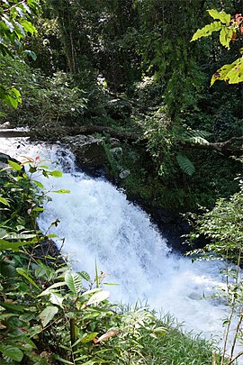
 Souita Falls, 2013 Souita Falls, 2013 | |||||||||||||||
 | |||||||||||||||
| Coordinates | 17°34′04″S 145°38′21″E / 17.5677°S 145.6391°E / -17.5677; 145.6391 (Middlebrook (centre of locality)) | ||||||||||||||
| Population | 62 (2021 census) | ||||||||||||||
| • Density | 2.756/km (7.14/sq mi) | ||||||||||||||
| Postcode(s) | 4886 | ||||||||||||||
| Area | 22.5 km (8.7 sq mi) | ||||||||||||||
| Time zone | AEST (UTC+10:00) | ||||||||||||||
| Location | |||||||||||||||
| LGA(s) | Tablelands Region | ||||||||||||||
| State electorate(s) | Hill | ||||||||||||||
| Federal division(s) | Kennedy | ||||||||||||||
| |||||||||||||||
Middlebrook is a rural locality in the Tablelands Region, Queensland, Australia. In the 2021 census, Middlebrook had a population of 62 people.
Geography
Middlebrook is on the Atherton Tableland with elevations ranging from 520 to 1,020 metres (1,710 to 3,350 ft).
The locality is bounded to the west by the road Beatrice Way (a segment of the old Palmerston Highway) and to the north and east by the Beatrice River.
The creek Middle Brook rises in neighbouring Beatrice to the west and flows through Middlebrook from the west to the south-east, exiting to Wooroonooran where it becomes a tributary of the Beatrice River and ultimately the Johnstone River, flowing into the Coral Sea.
The north, east and south-west of the locality are the higher more mountainous areas and are undeveloped land. The west, centre, and south of the locality are low-lying flatter where the land use is grazing on native vegetation.
History
In 1922, local people requested a school in Middlebrook, claiming there were 25 children in the district. However, it was not until January 1935 that a site was chosen and approval was given to erect a school building capable of accommodating 40 students. It was also necessary to extend Middlebrook Road and build a bridge over a creek to make the school accessible. Middlebrook Road State School (also known as Middlebook State School) opened on 2 September 1935 with Charles Mathew Connolly as the first head teacher. It closed circa 14 December 1945. The school building was relocated to Millaa Millaa State School and a bus service was provided to transport the students to Millaa Millaa to attend school each day. The school was located on the eastern corner of Middlebrook Road and Barter Road (approx 17°33′47″S 145°38′26″E / 17.56298°S 145.64042°E / -17.56298; 145.64042 (Middlebrook Road State School (former))).
Demographics
In the 2016 census, Middlebrook had a population of 55 people.
In the 2021 census, Middlebrook had a population of 62 people.
Education
There are no schools in Middlebrook. The nearest government primary school is Millaa Millaa State School in neighbouring Millaa Millaa to the north. The nearest government secondary school is Ravenshoe State High School in Ravenshoe to south-west.
Attractions
There are two waterfalls on Middle Brook:
- Papina Falls (also called Pepina Falls) off Beatrice Way (17°34′12″S 145°36′33″E / 17.57°S 145.6091°E / -17.57; 145.6091 (Papina Falls))
- Souita Falls off Barter Road (17°33′55″S 145°38′37″E / 17.5652°S 145.6436°E / -17.5652; 145.6436 (Souita Falls))
References
- ^ Australian Bureau of Statistics (28 June 2022). "Middlebrook (SAL)". 2021 Census QuickStats. Retrieved 28 February 2023.

- "Middlebrook – locality in Tablelands Region (entry 48755)". Queensland Place Names. Queensland Government. Retrieved 30 October 2019.
- ^ "Queensland Globe". State of Queensland. Retrieved 24 November 2023.
- "New Name for Old Palmerston Highway". The Express Newspaper Mareeba, Atherton, Cooktown, Kuranda, the Tablelands & the Far North. 17 January 2020. Archived from the original on 20 November 2023. Retrieved 24 November 2023.
- "Middle Brook – watercourse in the TablelandsRegion (entry 21813)". Queensland Place Names. Queensland Government. Retrieved 25 November 2023.
- "NEWS OF THE NORTH". Cairns Post. Vol. XXXV, no. 4450. Queensland, Australia. 16 December 1922. p. 12. Archived from the original on 24 November 2023. Retrieved 25 November 2023 – via National Library of Australia.
- "STATE SCHOOL". Cairns Post. No. 10, 284. Queensland, Australia. 23 January 1935. p. 8. Archived from the original on 24 November 2023. Retrieved 25 November 2023 – via National Library of Australia.
- "MIDDLEBROOK". Cairns Post. No. 10, 445. Queensland, Australia. 31 July 1935. p. 6. Archived from the original on 24 November 2023. Retrieved 25 November 2023 – via National Library of Australia.
- Queensland Family History Society (2010), Queensland schools past and present (Version 1.01 ed.), Queensland Family History Society, ISBN 978-1-921171-26-0
- "Agency ID 8799, Middlebrook Road State School". Queensland State Archives. Retrieved 1 November 2019.
- "MILLAA MILLAA NOTES". Cairns Post. No. 13, 492. Queensland, Australia. 30 May 1945. p. 4. Archived from the original on 24 November 2023. Retrieved 25 November 2023 – via National Library of Australia.
- "Palmerston" (Map). Queensland Government. 1944. Archived from the original on 24 November 2023. Retrieved 25 November 2023.
- "Queensland Two Mile series sheet 2m404" (Map). Queensland Government. 1943. Archived from the original on 8 October 2023. Retrieved 25 November 2023.
- Australian Bureau of Statistics (27 June 2017). "Middlebrook (SSC)". 2016 Census QuickStats. Retrieved 20 October 2018.

- "Papina Falls – waterfall in Tablelands Regional (entry 26018)". Queensland Place Names. Queensland Government. Retrieved 2 October 2023.
- "Papina Falls (aka Pepina Falls)" (Map). Google Maps. November 2022. Retrieved 25 November 2023.
- "Pepina Falls". Cairns & Great Barrier Reef. Archived from the original on 13 November 2023. Retrieved 24 November 2023.
- "Souita Falls – waterfall in Tablelands Regional (entry 31411)". Queensland Place Names. Queensland Government. Retrieved 2 October 2023.
- "Souita Falls" (Map). Google Maps. October 2021. Retrieved 25 November 2023.
- "Souita Falls". Cairns & Great Barrier Reef. Archived from the original on 13 November 2023. Retrieved 24 November 2023.