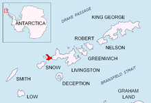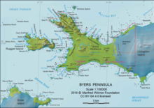


Midge Lake is the largest among numerous freshwater lakes on the ice-free Byers Peninsula, Livingston Island in the South Shetland Islands, Antarctica. The feature is arcuate in shape, extending 575 m in southwest-northeast direction and 125 m wide, surmounted by Chester Cone on the southeast, and draining through a 2 km stream north-northeastwards into Baba Tonka Cove.
The lake's name derives from the chironomid midge Belgica antarctica, a rare and localized insect in the South Shetlands, the imagos of which are found beneath the surrounding rock debris in summer.
Location
Midge Lake is centred at 62°37′49″S 61°05′42″W / 62.63028°S 61.09500°W / -62.63028; -61.09500 which is 860 m northwest of Chester Cone and 1.19 km southeast of President Hill (British mapping in 1968, detailed Spanish mapping in 1992, and Bulgarian mapping in 2005 and 2009).
Maps
- Península Byers, Isla Livingston. Mapa topográfico a escala 1:25000. Madrid: Servicio Geográfico del Ejército, 1992.
- L. Ivanov et al. Antarctica: Livingston Island and Greenwich Island, South Shetland Islands. Scale 1:100000 topographic map. Sofia: Antarctic Place-names Commission of Bulgaria, 2005.
- L. Ivanov. Antarctica: Livingston Island and Greenwich, Robert, Snow and Smith Islands. Scale 1:120000 topographic map. Troyan: Manfred Wörner Foundation, 2009. ISBN 978-954-92032-6-4
- L. Ivanov. Antarctica: Livingston Island and Smith Island. Scale 1:100000 topographic map. Manfred Wörner Foundation, 2017. ISBN 978-619-90008-3-0
References
This Livingston Island location article is a stub. You can help Misplaced Pages by expanding it. |