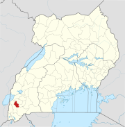
Place in Western Region of Uganda, Uganda
| Mitooma | |
|---|---|
 | |
| Coordinates: 00°36′54″S 30°02′42″E / 0.61500°S 30.04500°E / -0.61500; 30.04500 | |
| Country | Uganda |
| Region | Western Region of Uganda |
| Sub-region | Ankole sub-region |
| District | Mitooma District |
| Elevation | 5,069 ft (1,545 m) |
| Population | |
| • Total | 6,000 |
Mitooma, also Mitoma, is a town in the Western Region of Uganda. It is the main municipal, administrative, and commercial center of Mitooma District.
Location
Mitooma Municipal Council is located in Ruhinda County, Mitooma District, Ankole sub-region, in Uganda's Western Region. This is approximately 23 kilometres (14 mi), by road, southwest of Bushenyi, the nearest large town. Mitooma is located approximately 77 kilometres (48 mi), by road, west of Mbarara, the largest city in the Ankole sub-region. The geographical coordinates of the town are 0°36'54.0"S, 30°02'42.0"E (Latitude:-0.6150; Longitude:30.0450). Mitooma sits at an average elevation of 1,545 metres (5,069 ft) above mean sea level.
Population

In 2015, Uganda Bureau of Statistics (UBOS) estimated the population of Mitooma Town Council at 5,700. In 2020, the population agency estimated the mid-year population of the town at 6,000 people. Of these, an estimated 3,100 (51.7 percent) were females and 2,900 (48.3 percent) males. UBOS calculated that the town's population increased at an average rate of 1.03 percent annually, between 2015 and 2020.
Points of interest
The following points of interest li within or close to Mitooma Town Council.
1. The offices of Mitooma Municipal Council
2. The headquarters of Mitooma District Administration
3. Mitooma Central Market
4. The western end of the tarmacked 12.5 kilometres (7.8 mi) Kashenyi–Mitooma Road, is located here.
5. The 31 kilometres (19 mi) Mitooma–Rukungiri Road, a heavily pot-holed dirt road starts here to end at Rukungiri, in Rukungiri District.
See also
References
- ^ Uganda Bureau of Statistics (14 June 2020). "The population development of Mitooma as well as related information and services" (Citypopulaion.de Quoting Uganda Bureau of Statistics). Citypopulation.de. Retrieved 6 February 2021.
- Places In The World (6 February 2021). "Mitooma Town Council is a municipality in Ruhinda County in Mitooma District in Western Region in Uganda". Places In The World. Retrieved 6 February 2021.
- "Road Distance Between Bushenyi, Uganda And Mitooma, Uganda, With Map" (Map). Google Maps. Retrieved 6 February 2021.
- "Road Distance Between Mbarara, Uganda And Mitooma, Uganda, With Map" (Map). Google Maps. Retrieved 6 February 2021.
- ^ "Location of Mitooma, Uganda" (Map). Google Maps. Retrieved 6 February 2021.
- Fallingrain (6 February 2021). "Elevation of Mitooma, Uganda". Fallingrain.com. Retrieved 6 February 2021.
- "Road Distance Between Mitooma, Uganda And Rukungiri, Uganda" (Map). Google Maps. Retrieved 6 February 2021.
External links
| Capital: Mitooma | ||
| Towns and villages |
|  |
| Transport |
| |
| Notable people | ||