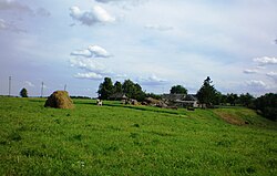
Village in Kaunas County, Lithuania
Mociūnai (formerly Polish : Maciuny , Russian : Мацюны) is a village in Kėdainiai district municipality , in Kaunas County , in central Lithuania . According to the 2011 census, the village had a population of 28 people. It is located 2.5 km from Kalnaberžė , by the deep valleys of Kruostas and Skaudinis rivers. There is an Old Believers cemetery in the village. Mociūnai Forest Botanical Sanctuary is located 2 km away from the village, in Kalnaberžė Forest.
Demography
Historical population Year Pop. ±% p.a. 1902 110 — 1923 151 +1.52% 1959 106 −0.98% 1970 122 +1.29%
Year Pop. ±% p.a. 1979 38 −12.16% 1989 26 −3.72% 2001 25 −0.33% 2011 28 +1.14%
Source: 1902 , 1923 , 1959 & 1970 , 1979 , 1989 , 2001 , 2011
Images
References
Maciuny ". Geographical Dictionary of the Kingdom of Poland 5 . Warszawa: Kasa im. Józefa Mianowskiego. 1884. p. 887.
"2011 census" . Statistikos Departamentas (Lithuania). Retrieved August 21, 2017.
Categories :
Text is available under the Creative Commons Attribution-ShareAlike License. Additional terms may apply.
**DISCLAIMER** We are not affiliated with Wikipedia, and Cloudflare.
The information presented on this site is for general informational purposes only and does not constitute medical advice.
You should always have a personal consultation with a healthcare professional before making changes to your diet, medication, or exercise routine.
AI helps with the correspondence in our chat.
We participate in an affiliate program. If you buy something through a link, we may earn a commission 💕
↑


