Unincorporated community in Colorado, United States
| Model, Colorado | |
|---|---|
| Unincorporated community | |
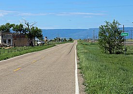
 Looking south along U.S. Route 350 in Model Looking south along U.S. Route 350 in Model | |
  | |
| Coordinates: 37°22′22″N 104°14′43″W / 37.37278°N 104.24528°W / 37.37278; -104.24528 | |
| Country | |
| State | |
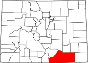
| County | Las Animas |
| Elevation | 5,617 ft (1,712 m) |
| Time zone | UTC-7 (MST) |
| • Summer (DST) | UTC-6 (MDT) |
| ZIP code | 81059 |
| Area code | 719 |
| GNIS feature ID | 0204809 |
Model is an abandoned unincorporated village in Las Animas County, Colorado, United States. The Model Post Office serving ZIP Code 81059 was in operation from 1912 to 2021, and was the last business or service standing there for many years. The community originally was a planned, or "model" community, hence the name.
Geography
Model is located at 37°22′22″N 104°14′43″W / 37.37278°N 104.24528°W / 37.37278; -104.24528 (37.372886,-104.245319).
References
- ^ "US Board on Geographic Names". United States Geological Survey. October 25, 2007. Retrieved January 31, 2008.
- ^ "ZIP Code Lookup". United States Postal Service. June 27, 2007. Archived from the original (JavaScript/HTML) on January 1, 2008. Retrieved June 27, 2007.
- "Post offices". Jim Forte Postal History. Retrieved July 1, 2016.
- Dawson, John Frank. Place names in Colorado: why 700 communities were so named, 150 of Spanish or Indian origin. Denver, CO: The J. Frank Dawson Publishing Co. p. 35.
| Municipalities and communities of Las Animas County, Colorado, United States | ||
|---|---|---|
| County seat: Trinidad | ||
| City |  | |
| Towns | ||
| CDPs | ||
| Unincorporated communities | ||
| Ghost towns | ||