Human settlement in England
| Monksilver | |
|---|---|
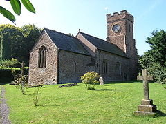
 Church of All Saints Church of All Saints | |
 | |
| Population | 113 (2011) |
| OS grid reference | ST072378 |
| District | |
| Shire county | |
| Region | |
| Country | England |
| Sovereign state | United Kingdom |
| Post town | Taunton |
| Postcode district | TA4 |
| Dialling code | 01984 |
| Police | Avon and Somerset |
| Fire | Devon and Somerset |
| Ambulance | South Western |
| UK Parliament | |
| 51°07′56″N 3°19′37″W / 51.1322°N 3.3270°W / 51.1322; -3.3270 | |
Monksilver is a village 3 miles (5 km) west of the town of Williton in Somerset, England, on the eastern flank of the Brendon Hills and the border of the Exmoor National Park. The Coleridge Way footpath passes through the village.
History
The name of the village means monk's wood. In the Domesday Book it was simply Selvre, from the Latin silva for a wood, although it has also been suggested that Sulfhere, in AD 897, referred to the silvery stream below the village.
In 1113 the manor was given by Robert de Chandos to endow Goldcliff Priory, which he had just established near Newport in Monmouthshire . In 1441 it passed, with the priory, to Tewkesbury Abbey and then in 1474 to the canons of Windsor. In the 14th century the name changed to "Monksilver".
The parish of Monksilver was part of the Williton and Freemanners Hundred. In the 16th and 17th centuries it was a centre for cloth making and field names such as "Rack", at nearby Woodford, suggest this activity.
Governance
The parish council has responsibility for local issues, including setting an annual precept (local rate) to cover the council's operating costs and producing annual accounts for public scrutiny. The parish council evaluates local planning applications and works with the local police, district council officers, and neighbourhood watch groups on matters of crime, security, and traffic. The parish council's role also includes initiating projects for the maintenance and repair of parish facilities, as well as consulting with the district council on the maintenance, repair, and improvement of highways, drainage, footpaths, public transport, and street cleaning. Conservation matters (including trees and listed buildings) and environmental issues are also the responsibility of the council.
The village falls within the non-metropolitan district of Somerset West and Taunton, which was established on 1 April 2019. It was previously in the district of West Somerset, which was formed on 1 April 1974 under the Local Government Act 1972, and part of Williton Rural District before that. The district council is responsible for local planning and building control, local roads, council housing, environmental health, markets and fairs, refuse collection and recycling, cemeteries and crematoria, leisure services, parks, and tourism.
Somerset County Council is responsible for running the largest and most expensive local services such as education, social services, libraries, main roads, public transport, policing and fire services, trading standards, waste disposal and strategic planning.
The village lies within the Tiverton and Minehead county constituency represented in the House of Commons of the Parliament of the United Kingdom. The constituency elects one Member of Parliament (MP) by the first past the post system of election.
Religious sites
Main article: Church of All Saints, MonksilverThe parish church, dedicated to All Saints, has a square tower containing five bells. Inside is an Easter sepulchre. The pulpit is 16th-century, the screen is Jacobean and the lectern is possibly older. The wagon roof is thought to be 13th-century and an alms box by the door is from 1634. It has been designated by English Heritage as a Grade I listed building. In 1583 Sir Francis Drake married his second wife Elizabeth Sydenham, of nearby Combe Sydenham in the parish of Stogumber, at the church.
Amenities
The village has a village hall (shared with the parishes of Nettlecombe and Elworthy), a telephone box and a newspaper hut. The village pub, The Notley Arms, serves locally sourced food. The village is served twice a week with a bus service connecting it to Taunton. The mobile library visits every three weeks.
The village lies on the route of both the Coleridge Way and Samaritans Way South West.
References
- "Statistics for Wards, LSOAs and Parishes — SUMMARY Profiles" (Excel). Somerset Intelligence. Retrieved 4 January 2014.
- Robinson, Stephen (1992). Somerset Place Names. Wimborne, Dorset: Dovecote Press. ISBN 1-874336-03-2.
- ^ Bush, Robin (1994). Somerset: The complete guide. Wimborne: The Dovecote Press Ltd. pp. 148–149. ISBN 1-874336-26-1.
- ^ "A History of the County of Somerset: Volume 5". British History Online. Retrieved 3 March 2012.
- "Somerset Hundreds". GENUKI. Retrieved 23 October 2011.
- "Williton RD". A vision of Britain Through Time. University of Portsmouth. Retrieved 5 January 2014.
- "All Saints' church in Monksilver". UK attractions. Archived from the original on 28 October 2007. Retrieved 17 November 2007.
- Historic England. "Church of All Saints (1296069)". National Heritage List for England. Retrieved 17 November 2007.
- "The Notley Arms". Archived from the original on 12 November 2011. Retrieved 30 March 2010.
- "Samaritans Way". Bristol Ramblers. Archived from the original on 4 March 2016. Retrieved 27 October 2015.
External links
![]() Media related to Monksilver at Wikimedia Commons
Media related to Monksilver at Wikimedia Commons
