Municipality in Quebec, Canada
| Mont-Carmel | |
|---|---|
| Municipality | |
 | |
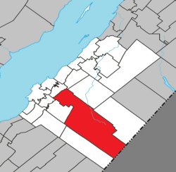
 Location within Kamouraska RCM Location within Kamouraska RCM | |
 | |
| Coordinates: 47°26′23″N 69°51′31″W / 47.43972°N 69.85861°W / 47.43972; -69.85861 | |
| Country | |
| Province | |
| Region | Bas-Saint-Laurent |
| RCM | Kamouraska |
| Constituted | July 1, 1855 |
| Government | |
| • Mayor | Pierre Saillant |
| • Federal riding | Montmagny—L'Islet—Kamouraska—Rivière-du-Loup |
| • Prov. riding | Côte-du-Sud |
| Area | |
| • Total | 438.60 km (169.34 sq mi) |
| • Land | 428.26 km (165.35 sq mi) |
| Population | |
| • Total | 1,160 |
| • Density | 2.7/km (7/sq mi) |
| • Pop 2016-2021 | |
| • Dwellings | 713 |
| Time zone | UTC−5 (EST) |
| • Summer (DST) | UTC−4 (EDT) |
| Postal code(s) | G0L 1W0 |
| Area code(s) | 418 and 581 |
| Highways | |
| Website | www |
Mont-Carmel (French pronunciation: [mɔ̃ kaʁmɛl]) is a municipality in the Canadian province of Quebec, located in the Kamouraska Regional County Municipality, on the Canada–United States border.
History
Mont-Carmel was created in 1855. Not long after its creation, the name became Notre-Dame-du-Mont-Carmel but, during the middle of the 20th century, the name was officialised as simply Mont-Carmel.
Geography
Spanning over 75% of the width of the Bas-Saint-Laurent region in which it resides, Mont-Carmel is the second largest subdivision within the Kamouraska Regional County Municipality and borders the United States at its southeast limit.
Communities and locations
The following designated areas reside within the municipality's boundaries:
- Eatonville – a hamlet located at 47°20′16″N 69°41′01″W / 47.33778°N 69.68361°W / 47.33778; -69.68361 (Eatonville, Mont-Carmel, QC)
- Lac-de-l'Est – a vacation cottage community located at 47°13′39″N 69°35′26″W / 47.22750°N 69.59056°W / 47.22750; -69.59056 (Lac-de-l'Est, Dundee, QC)
Government
Municipal council
- Mayor: Pierre Saillant
- Councillors: Ghislain Dionne, Lucien Dionne, Josée-Ann Dumais, Denis Lévesque, Mélanie Lévesque, Réjeanne Raymond-Roussel
See also
References
- ^ "Banque de noms de lieux du Québec: Reference number 42055". toponymie.gouv.qc.ca (in French). Commission de toponymie du Québec.
- ^ "Répertoire des municipalités: Geographic code 14005". www.mamh.gouv.qc.ca (in French). Ministère des Affaires municipales et de l'Habitation.
- ^ "Census Profile, 2021 Census, Statistics Canada - Validation Error".
External links
 Media related to Mont-Carmel, Quebec at Wikimedia Commons
| Adjacent Municipal Subdivisions | |
|---|---|
| Cities and towns | |
|---|---|
| Municipalities | |
| Parishes | |
| Unorganized territories | |
| |