| Montalet-le-Bois | |
|---|---|
| Commune | |
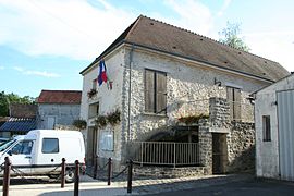
 The town hall in Montalet-le-Bois, located in the old mill The town hall in Montalet-le-Bois, located in the old mill | |
 Coat of arms Coat of arms | |
| Location of Montalet-le-Bois | |
  | |
| Coordinates: 49°02′50″N 1°49′36″E / 49.0472°N 1.8267°E / 49.0472; 1.8267 | |
| Country | France |
| Region | Île-de-France |
| Department | Yvelines |
| Arrondissement | Mantes-la-Jolie |
| Canton | Limay |
| Intercommunality | CU Grand Paris Seine et Oise |
| Government | |
| • Mayor (2021–2026) | Maël Wotin |
| Area | 3.01 km (1.16 sq mi) |
| Population | 319 |
| • Density | 110/km (270/sq mi) |
| Time zone | UTC+01:00 (CET) |
| • Summer (DST) | UTC+02:00 (CEST) |
| INSEE/Postal code | 78416 /78440 |
| Elevation | 66–180 m (217–591 ft) (avg. 128 m or 420 ft) |
| French Land Register data, which excludes lakes, ponds, glaciers > 1 km (0.386 sq mi or 247 acres) and river estuaries. | |
Montalet-le-Bois (French pronunciation: [mɔ̃talɛ lə bwa]) is a commune in the Yvelines department in the Île-de-France region in north-central France.
See also
References
- "Répertoire national des élus: les maires" (in French). data.gouv.fr, Plateforme ouverte des données publiques françaises. 13 September 2022.
- "Populations légales 2021" (in French). The National Institute of Statistics and Economic Studies. 28 December 2023.
This Yvelines geographical article is a stub. You can help Misplaced Pages by expanding it. |