| Montgomery Peak | |
|---|---|
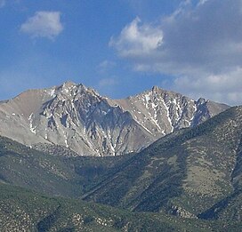
 Montgomery Peak (right) and Boundary Peak Montgomery Peak (right) and Boundary Peak | |
| Highest point | |
| Elevation | 13,447 ft (4,099 m) NAVD 88 |
| Prominence | 1,266 ft (386 m) |
| Listing |
|
| Coordinates | 37°50′18″N 118°21′24″W / 37.8382642°N 118.3567847°W / 37.8382642; -118.3567847 |
| Geography | |
 | |
| Location | |
| Parent range | White Mountains |
| Topo map | USGS Boundary Peak |
| Climbing | |
| Easiest route | Scramble, class 2 |
Montgomery Peak is a mountain in the White Mountains of California, USA. It is less than 1 mile (1.6 km) from Boundary Peak, the highest point in Nevada; and it is taller than Boundary Peak. Boundary Peak has a prominence of less than 300 feet. Montgomery can be climbed in combination with Boundary Peak. The two peaks are in the Inyo National Forest and White Mountains Wilderness. Montgomery Peak is in Mono County (California), and Boundary Peak is in Esmeralda County, in Nevada.
References
- ^ "Montgomery Peak, California". Peakbagger.com. Retrieved 2009-02-17.
- ^ "Desert Peaks Section List" (PDF). Angeles Chapter, Sierra Club. Retrieved 2014-02-23.
- "Great Basin Peaks Section List". Toiyabe Chapter, Sierra Club. Retrieved 2021-11-21.
- "Western States Climbers Qualifying Peak List". Climber.org. Retrieved 2021-11-21.
- "Montgomery Peak". Geographic Names Information System. United States Geological Survey, United States Department of the Interior. Retrieved 2009-02-17.
This Mono County, California-related article is a stub. You can help Misplaced Pages by expanding it. |