| This article needs additional citations for verification. Please help improve this article by adding citations to reliable sources. Unsourced material may be challenged and removed. Find sources: "Most pri Bratislave" – news · newspapers · books · scholar · JSTOR (February 2013) (Learn how and when to remove this message) |
| Most pri Bratislave | |
|---|---|
| Municipality | |
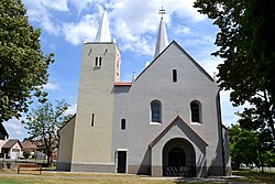
 Church of the Sacred Heart Church of the Sacred Heart | |
  | |
| Coordinates: 48°08′27″N 17°16′10″E / 48.14083°N 17.26944°E / 48.14083; 17.26944 | |
| Country | Slovakia |
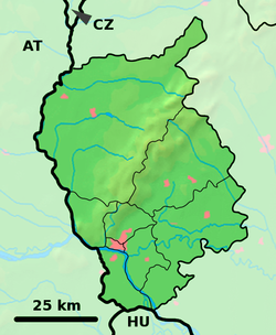
| Region | Bratislava |
| District | Senec |
| First mentioned | 1283 |
| Area | |
| • Total | 19.01 km (7.34 sq mi) |
| Elevation | 130 m (430 ft) |
| Population | |
| • Total | 4,094 |
| Postal code | 900 46 |
| Area code | +421 18 |
| Car plate | SC |
| Website | www.mostpribratislave.sk |
Most pri Bratislave (Hungarian: Dunahidas, German: Bruck) is a village and municipality in western Slovakia in Senec District in the Bratislava Region.
History
In historical records the village was first mentioned with the German name Pruck in 1238. The village once belonged to the German language area but the majority of the German population was expelled at the end of World War II.
Geography
The municipality lies at an altitude of 130 metres above sea level and covers an area of 19.01 km.
Demographics
According to the 2011 census, the municipality had 2,144 inhabitants. 1,883 of inhabitants were Slovaks, 41 Hungarians, 20 Czechs and 200 others and unspecified.
According to the 2021 census, the population has increased to 3,913, 87% of whom were Slovaks and 2% Hungarians.
References
- "Počet obyvateľov podľa pohlavia - obce (ročne)". www.statistics.sk (in Slovak). Statistical Office of the Slovak Republic. 2022-03-31. Retrieved 2022-03-31.
- ^ "Hustota obyvateľstva - obce [om7014rr_ukaz: Rozloha (Štvorcový meter)]". www.statistics.sk (in Slovak). Statistical Office of the Slovak Republic. 2022-03-31. Retrieved 2022-03-31.
- ^ "Základná charakteristika". www.statistics.sk (in Slovak). Statistical Office of the Slovak Republic. 2015-04-17. Retrieved 2022-03-31.
- ^ "Hustota obyvateľstva - obce". www.statistics.sk (in Slovak). Statistical Office of the Slovak Republic. 2022-03-31. Retrieved 2022-03-31.
- Im Strom der Zeit: Bruck an der Donau, Retrieved 2023-04-18.
- http://portal.statistics.sk/files/obce-narodnost.pdf Archived 2014-10-06 at the Wayback Machine
- "Experience". gis.scitanie.sk. Retrieved 25 January 2023.
External links/Sources
![]() Media related to Most pri Bratislave at Wikimedia Commons
Media related to Most pri Bratislave at Wikimedia Commons
- Official page
- https://web.archive.org/web/20070513023228/http://www.statistics.sk/mosmis/eng/run.html
This Bratislava location article is a stub. You can help Misplaced Pages by expanding it. |