| Cobberas Range | |
|---|---|
 | |
| Highest point | |
| Peak | Cobberas No. 1, Alpine National Park |
| Elevation | 1,810 m (5,940 ft) AHD |
| Coordinates | 36°51′44″S 148°09′05″E / 36.86222°S 148.15139°E / -36.86222; 148.15139 |
| Geography | |
| Country | Australia |
| State | Victoria |
| Parent range | Great Dividing Range |
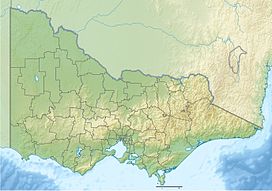
The Cobberas Range, a mountain range that is part of the Great Dividing Range within the Victorian Alps, is located in north-eastern Victoria in Australia. The range is located in the Cobberas Wilderness area of the Alpine National Park.
Peaks include:
- Mount Cobberas No. 1, at 1,810 metres (5,940 ft)
- Mount Cobberas No. 2
- Moscow Peak
- Middle Peak
- Cleft Peak
In January 1854, Victorian Government Botanist Ferdinand von Mueller passed through the area on the second of his three expeditions to the Alps. He collected many plants, many of which had not been previously recorded.
See also
References
- ^ "Mount Cobberas, Australia". Peakbagger.com. Retrieved 7 August 2014.
- "Mount Cobberas No. 1: 13133". Vicnames. 2 May 1966. Archived from the original on 11 August 2014. Retrieved 7 August 2014.
- ^ "8524-10 Amphitheatre - Mt Cobberas". Victorian Resources Online - East Gippsland. Department of Primary Industries (Victoria). Retrieved 4 July 2011.
- "Source of the Rivers - around Mitta Mitta, Omeo, Tallangatta and Corryong (map)" (PDF). Alpine National Park. Archived from the original (PDF) on 6 April 2011. Retrieved 3 July 2011.
- Slattery, Deirdre (1998). The Australian Alps: Kosciuszko, Alpine and Namadgi National Parks. Sydney: University of New South Wales Press. pp. 106–107. ISBN 0-86840-319-9.
| Mountains in Victoria, Australia | |||||||||||
|---|---|---|---|---|---|---|---|---|---|---|---|
| Grampians | |||||||||||
| Victorian Alps |
| ||||||||||
| Other mountain ranges |
| ||||||||||
This article about a location in Victoria, Australia is a stub. You can help Misplaced Pages by expanding it. |