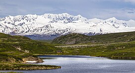
| Mount Gakona | |
|---|---|
 Southwest aspect centered at top Southwest aspect centered at top | |
| Highest point | |
| Elevation | 9,865 ft (3,007 m) |
| Prominence | 2,313 ft (705 m) |
| Parent peak | Mount Kimball (10,300 ft) |
| Isolation | 7.73 mi (12.44 km) |
| Coordinates | 63°19′21″N 145°10′51″W / 63.3225394°N 145.1807369°W / 63.3225394; -145.1807369 |
| Geography | |
 | |
| Interactive map of Mount Gakona | |
| Country | United States |
| State | Alaska |
| Census Area | Southeast Fairbanks |
| Parent range | Alaska Range Delta Mountains |
| Topo map | USGS Mount Hayes B-3 |
| Climbing | |
| First ascent | 1970 |
Mount Gakona is a 9,865-foot-elevation (3,007-meter) mountain summit in Alaska.
Description
Mount Gakona is located 22 miles (35 km) northeast of Paxson in the Delta Mountains which are a subrange of the Alaska Range. The heavily glaciated mountain ranks as the fourth-highest peak in the Delta Mountains. Precipitation runoff and glacial meltwater from the mountain's north slope drains to Johnson Glacier → Johnson River → Tanana River, whereas the south slope drains to the Gakona Glacier → Gakona River → Copper River. Topographic relief is significant as the summit rises 4,865 feet (1,483 meters) above the Johnson Glacier in 1.3 mile (2.1 km). The first ascent of the summit was made on March 24, 1980, by Daniel Osborne, Steve O'Brien, Mark Hottman, and Toby Wheeler. The climbers reported that the mountain has two peaks separated one mile apart by a knife-edged ridge. The word "Gakona" /ɡəˈkoʊnə/ (Ggax Kuna' in Ahtna language) means "rabbit" or "rabbit river." The mountain's toponym has been officially adopted by the United States Board on Geographic Names.
Climate
According to the Köppen climate classification system, Mount Gakona is located in a tundra climate zone with cold, snowy winters, and cool summers. Weather systems are forced upwards by the Delta Mountains (orographic lift), causing heavy precipitation in the form of rainfall and snowfall. Winter temperatures can drop below 0 °F with wind chill factors below −10 °F. This climate supports the Johnson Glacier, Gakona Glacier, and smaller unnamed glaciers surrounding the peak.
See also
References
- ^ "Mount Gakona, Peakvisor.com". Retrieved 2023-12-22.
- ^ "Gakona, Mount - 9,850' AK". listsofjohn.com. Retrieved 2023-12-22.
- ^ "Mount Gakona". Geographic Names Information System. United States Geological Survey, United States Department of the Interior. Retrieved 2023-12-22.
- ^ "Mount Gakona, Alaska". Peakbagger.com. Retrieved 2023-12-22.
- Franz Mueter, Club History, Alaskaalpineclub.com, Retrieved 2023-12-22.
- Daniel Osborne, North America, United States, Alaska, Mount Gakona, Eastern Alaska Range, 1971, publications.americanalpineclub.org, Retrieved 2023-12-22.
- University of Alaska Fairbanks: Alaska Native Place Names, Retrieved 2023-12-22.
- Sandy Nestor, Indian Placenames in America, Volume 1, McFarland, 2015, ISBN 9780786493395, p. 11.
- Donald J. Orth, Dictionary of Alaska Place Names, U.S. Government Printing Office, 1967, page 358.
- Peel, M. C.; Finlayson, B. L.; McMahon, T. A. (2007). "Updated world map of the Köppen−Geiger climate classification". Hydrol. Earth Syst. Sci. 11. ISSN 1027-5606.
External links
- Mount Gakona: weather forecast
- Mount Gakona (photo): Flickr